North Otterington
| North Otterington | |
|---|---|
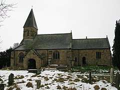 St Michael and All Saints, North Otterington | |
 North Otterington North Otterington shown within North Yorkshire | |
| OS grid reference | SE362897 |
| Civil parish |
|
| District | |
| Shire county | |
| Region | |
| Country | England |
| Sovereign state | United Kingdom |
| Post town | NORTHALLERTON |
| Postcode district | DL7 |
| Police | North Yorkshire |
| Fire | North Yorkshire |
| Ambulance | Yorkshire |
| EU Parliament | Yorkshire and the Humber |
North Otterington is a village and civil parish in the Hambleton district of North Yorkshire, England, which lies on the east bank of the River Wiske.[1] The population of the village was estimated by North Yorkshire County Council as being 40, with a slight decline to 30 by 2015.[2] Details are also included in the civil parish of Ainderby Steeple.[3] It is on the A167 road and 3 miles (4.8 km) south of Northallerton; South Otterington is further south on the same road.[4]
The name of the village is from Old English (Oter's Tun) and means the town of Oter's people. It was recorded in the Domesday Book as Otrinctun in the Hundred (Wapentake) of Allerton.[5][6]
The Church of St Michael and All Angels dates back to the 12th century, though most parts were expanded in the 14th, 17th and 19th centuries. Whilst the site was important back to Saxon times (Saxon coffins and swords were unearthed in the 19th century restoration), the first vicar was not recorded until 1282.[7] For many years, St Michael's was the Mother Church in the parish and wider area and Corpse roads extended from nearby Thornton-le-Moor and Thornton le Beans; these are still marked on modern day Ordnance Survey maps.[4][8] The building is now grade II listed and is used for services on three Sundays of each month.[9][10]
References
- ↑ "History of North Otterington, in Hambleton and North Riding | Map and description". www.visionofbritain.org.uk. Retrieved 13 May 2018.
- ↑ "2015 Population Estimates Parishes" (PDF). northyorks.gov.uk. p. 11. Retrieved 13 May 2018.
- ↑ UK Census (2011). "Local Area Report – Ainderby Steeple Parish (1170216793)". Nomis. Office for National Statistics. Retrieved 13 May 2018.
- 1 2 "302" (Map). Northallerton & Thirsk. 1:25,000. Explorer. Ordnance Survey. 2015. ISBN 9780319245545.
- ↑ Ekwall, Eilert (1960). The concise Oxford dictionary of English place-names (4 ed.). Oxford: Clarendon Press. p. 353. ISBN 0-19-869103-3.
- ↑ Powell-Smith, Anna. "[North] Otterington | Domesday Book". opendomesday.org. Retrieved 13 May 2018.
- ↑ "Genuki: ECCLESIASTICAL HISTORY., Yorkshire (North Riding)". www.genuki.org.uk. Retrieved 13 May 2018.
- ↑ "Parishes: North Otterington | British History Online". www.british-history.ac.uk. Retrieved 13 May 2018.
- ↑ Historic England. "Church of St Michael and All Angles, North Otterington (Grade II) (1150954)". National Heritage List for England. Retrieved 13 May 2018.
- ↑ "About us - St Michael & All Angels -A Church Near You". www.achurchnearyou.com. Retrieved 13 May 2018.
External links
![]()