North Guwahati
| North Guwahati Durjaya (Ancient) | |
|---|---|
| Neighbourhood | |
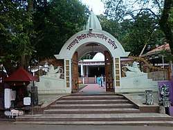 The Doul Govinda Temple is important landmark of the town | |
 North Guwahati Location in Assam, India  North Guwahati North Guwahati (India) | |
| Coordinates: 26°11′N 91°43′E / 26.18°N 91.72°ECoordinates: 26°11′N 91°43′E / 26.18°N 91.72°E | |
| Country |
|
| State | Assam |
| District | Kamrup Rural district[1] |
| Government | |
| • Body | North Guwahati Town Committee |
| Elevation | 33 m (108 ft) |
| Population (2001) | |
| • Total | 16,131 |
| Languages | |
| • Official | Assamese |
| • Native | Kamrupi |
| Time zone | UTC+5:30 (IST) |
| PIN | 781 XXX |
| Vehicle registration | AS |
| Website |
kamrup |
North Guwahati is northern part of the city of Guwahati and a town area committee in Kamrup rural district in the Indian state of Assam.This town is abounds in historical places and picnic spots. National Highway 27 passes through North Guwahati.
History
North Guwahati also known as Durjaya, was capital of ancient state of Kamarupa under Pala dynasty.[2] In early medieval times area was known as Kamarupa Nagara. North Guwahati possesses temples, roads, bridges, fortifications and moats which are of ancient origin. There are two temples on the Aswakranta hill. The upper temple contains the image of Vishnu lying on Ananta-Sajya. It is one of the finest specimens of sculptural skill in Kamarupa about the beginning of the twelfth century.
The western part of the town is called Sil-Sako because it still contains a small stone-built bridge over a stream. The eastern part is known as Raja-duar (king's gate), which shows that the Raja's palace was there. The second copper-plate of Dharma Pala was found in the village of Rangmahal about two miles to the north of Raja-duar. This is another indication that the capital was then at North-Guwahati. In Rajaduur itself exists the rock-inscription, dated 1127 Saka, proclaiming the destruction of the Turkish army of Mahammad Bukhtiyar.
North Guwahati continued to be the capital from the time of Dharma Pala till about 1260 A.D. when the seat of government was transferred to further west. The stone-slab inscriptioun found on the hill in Raja-duar, abutting on the Brahmaputra, it can found that this small hill was the abode of Sri Chandra Bharati, a well-known Kamrupi poet of the sixteenth century.[3]
Geography
North Guwahati is located at 26°11′N 91°43′E / 26.18°N 91.72°E.[4] It has an average elevation of 54 m (177 ft).
Demography
As of 2001 India census,[5] North Guwahati had a population of 16,131. Males constitute 53% of the population and females 47%. North Guwahati has an average literacy rate of 73%, higher than the national average of 59.5%: male literacy is 78%, and female literacy is 68%. In North Guwahati, 10% of the population is under 6 years of age.
Education
The Indian Institute of Technology, Guwahati, the sixth in country, was set up in the year 1994. Covering 285 hectares of area, it is situated here amidst scenic hills and lakes. It is the sole Indian Institutes of Technology in the region.
Places of interest
North Guwahati abounds with historical temples like Dirgheshwari temple, Doul Govinda Temple, Janardan temple, Mani-Karneswar Temple, Aswaklanta Temple, Rudreswar Temple, Auniati Satra, etc. Goddess Durga is worshipped in the Dirgheswari Temple. Surrounded by evergreen trees and a fast-flowing brook, it is a beautiful spot for picnic. Another beautiful spot is Manikoreneswar Temple situated on a hill on the back of the river Brahmaputra. Aswaklanta, another historical place, stands on the bank of the river Brahmaputra.
Commerce
The town is major commercial hub, with major industries are located here with numerous factories.
References
- ↑ "Boundary Map of Kamrup". kamrup.nic.in. Retrieved 28 August 2015.
- ↑ North East India History Association, Proceedings of North East India History Association
- ↑ Kanak Lal Barua, Early History of Kamarupa (1933)
- ↑ Falling Rain Genomics, Inc - North Gauhati Archived 2008-01-23 at the Wayback Machine.
- ↑ "Census of India 2001: Data from the 2001 Census, including cities, villages and towns (Provisional)". Census Commission of India. Archived from the original on 2004-06-16. Retrieved 2008-11-01.