North Curl Curl, New South Wales
| North Curl Curl Sydney, New South Wales | |||||||||||||||
|---|---|---|---|---|---|---|---|---|---|---|---|---|---|---|---|
 North Curl Curl from Wingala Reserve | |||||||||||||||
| Population | 4,117 (2016 census)[1] | ||||||||||||||
| Postcode(s) | 2099 | ||||||||||||||
| Location | 19 km (12 mi) north-east of Sydney CBD | ||||||||||||||
| LGA(s) | Northern Beaches Council | ||||||||||||||
| State electorate(s) | Manly [2] | ||||||||||||||
| Federal Division(s) | Warringah | ||||||||||||||
| |||||||||||||||
North Curl Curl is a suburb in northern Sydney, in the state of New South Wales, Australia 19 kilometres north-east of the Sydney central business district, in the local government area of Northern Beaches Council. It is part of the Northern Beaches region.
History
Curl Curl may be derived from the Aboriginal phrase curial curial, meaning river of life.[3]
The name Curl Curl Lagoon was originally applied to Manly Lagoon, which empties into the ocean at Queenscliff, and the current Curl Curl Lagoon was named Harbord Lagoon. This was a result of the land grant of 'Harbord' originally being much larger than the suburb that later bore this name. The names were changed as a part of a renaming program in the 1980s to reflect the true location of the lagoons.[4]
North Curl Curl Post Office opened on 10 June 1923 and was renamed Curl Curl North in 1948.[5]
Population
In the 2016 Census, there were 4,117 people in North Curl Curl. 70.3% of people were born in Australia. The next most common country of birth was England at 8.5%. 84.7% of people only spoke English at home. The most common responses for religion were No Religion 33.5%, Catholic 26.4% and Anglican 20.5%.[1]
Geography
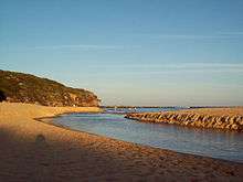
Curl Curl Lagoon and Greendale Creek separate North Curl Curl from Curl Curl in the south. To the west the border with Brookvale runs along Harbord Road. Wingala is an 'urban place' as classified by the Geographical Names Board in the north and western parts of the suburb, lying on the southern slopes of a hill that overlaps into Dee Why. Headland Road marks the northern boundary, while the Tasman Sea lies to the east.
North Curl Curl Beach sits on the south-eastern border, south of Dee Why Head and lying under its cliffs, and is divided from Curl Curl Beach by the mouth of the lagoon. The suburb is generally characterised by the sometimes steep southern slopes of Wingala Hill and Dee Why Head to the north, which flatten out into the former floodplain of the lagoon towards the south.
Sport and recreation
The North Curl Curl Surf Life Saving Club patrol North Curl Curl Beach. North Curl Curl Knights are the local rugby league side, with the colours of green and gold.
Sport and recreation facilities exist in the extensive parks and playing fields areas to the north of the Lagoon, including the Bowling Club (formerly the Curl Curl Women's Bowling Club but now run by Dee Why RSL Club), Curl Curl Youth Club, soccer fields, baseball fields, cricket pitches, netball courts, as well as rugby league and rugby union fields.
Schools
North Curl Curl has two public schools, Curl Curl North Public School and Manly Selective Campus of the Northern Beaches Secondary College, formerly Manly Boys High School.
References
- 1 2 Australian Bureau of Statistics (27 June 2017). "North Curl Curl (State Suburb)". 2016 Census QuickStats. Retrieved 4 December 2017.

- ↑ "NSW EC - Manly". Electoral Commission NSW. Retrieved 2007-07-01.
- ↑ "Curl Curl". Geographical Names Register (GNR) of NSW. Geographical Names Board of New South Wales. Retrieved 2007-09-10.
- ↑ "Manly Daily article". Cumberland newspapers. Retrieved 2007-12-10.
- ↑ Premier Postal History. "Post Office List". Premier Postal Auctions. Retrieved 12 June 2012.
Coordinates: 33°45′52″S 151°17′50″E / 33.7645°S 151.2973°E