Nobeyama Station
Nobeyama Station 野辺山駅 | |
|---|---|
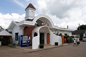 Nobeyama Station in August 2011 | |
| Location |
306 Nobeyama, Minamimaki-mura, Minamisaku-gun, Nagano-ken 384-1305 Japan |
| Elevation | 1,345.67 m |
| Operated by |
|
| Line(s) | ■ Koumi Line |
| Distance | 23.4 km from Kobuchizawa |
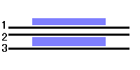
| Platforms | 1 side + 1 island platform |
| Tracks | 3 |
| Other information | |
| Website | Official website |
| History | |
| Opened | 29 November 1935 |
| Rebuilt | 1983 |
| Traffic | |
| Passengers (FY2015) | 165 daily |
| Location | |
 Nobeyama Station Location within Japan | |
Nobeyama Station (野辺山駅 Nobeyama-eki) is a railway station on the Koumi Line in the village of Minamimaki in Nagano Prefecture, Japan, operated by the East Japan Railway Company (JR East). The station is the highest JR station in Japan.
Lines
Nobeyama Station is served by the 78.9 km (49.0 mi) Koumi Line and is 23.4 km (14.5 mi) from the starting point of the line at Kobuchizawa Station.[1]
Station layout
The station consists of one side platform and one island platform, serving three tracks, connected by a level crossing. The station has a Midori no Madoguchi staffed ticket office. A sign on the platform proclaims it to be the highest JR station in Japan, located at 1,345.67 m (4,414.9 ft) above sea level.[1]
Platforms
| 1 | ■ Koumi Line | for Sakudaira and Komoro |
| 2 | ■ Koumi Line | for Kiyosato and Kobuchizawa |
| 3 | ■ Koumi Line | (passing loop) |
 →:for Komuro
←:for Kobuchizawa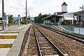 The platforms in August 2011
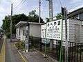 The platform in August 2008, with the sign indicating the altitude of 1,345.67 m above sea level
Adjacent stations
| « | Service | » | ||
|---|---|---|---|---|
| Koumi Line | ||||
| Kiyosato | Local | Shinano-Kawakami | ||
History
Nobeyama Station opened on 29 November 1935.[2] With the privatization of Japanese National Railways (JNR) on 1 April 1987, the station came under the control of JR East.[2] The current station building was completed in March 1983.[1]
Passenger statistics
In fiscal 2015, the station was used by an average of 165 passengers daily (boarding passengers only).[3]
Surrounding area
- Nobeyama radio observatory
- National Route 141
- Nobeyama SL Land
See also
- List of railway stations in Japan
- Murodō Station (the highest altitude station in Japan)
- Yoshioka-Kaitei Station (deepest underground station in Japan)
- Yatomi Station (overground station with the lowest altitude in Japan)
References
- 1 2 3 Uchiyama, Kunio, ed. (20 June 2009). 長野県鉄道全駅 [The databook of all railroad stations in Nagano] (in Japanese). Japan: The Shinano Mainichi Shimbun. p. 148. ISBN 978-4-7840-7112-8.
- 1 2 Ishino, Tetsu, ed. (1998). 停車場変遷大辞典 国鉄・JR編 [Station Transition Directory - JNR/JR] (in Japanese). II. Japan: JTB. p. 201. ISBN 4-533-02980-9.
- ↑ 各駅の乗車人員 (2015年度) [Station passenger figures (Fiscal 2015)] (in Japanese). Japan: East Japan Railway Company. 2016. Retrieved 5 July 2016.
External links
| Wikimedia Commons has media related to Nobeyama Station. |
- Official website (in Japanese)
Coordinates: 35°57′19″N 138°28′28″E / 35.955327°N 138.4745°E