Newtonville station
NEWTONVILLE | |||||||||||||||||||||||||||||||
|---|---|---|---|---|---|---|---|---|---|---|---|---|---|---|---|---|---|---|---|---|---|---|---|---|---|---|---|---|---|---|---|
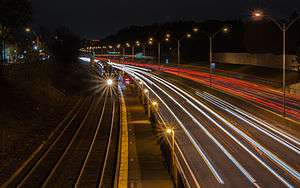 An outbound train arriving at Newtonville at night | |||||||||||||||||||||||||||||||
| Location |
770 Washington Street Newtonville, Massachusetts | ||||||||||||||||||||||||||||||
| Coordinates | 42°21′06″N 71°12′19″W / 42.35170°N 71.20525°WCoordinates: 42°21′06″N 71°12′19″W / 42.35170°N 71.20525°W | ||||||||||||||||||||||||||||||
| Owned by | MBTA | ||||||||||||||||||||||||||||||
| Line(s) | Worcester Line | ||||||||||||||||||||||||||||||
| Platforms | 1 side platform | ||||||||||||||||||||||||||||||
| Tracks | 2 | ||||||||||||||||||||||||||||||
| Connections |
| ||||||||||||||||||||||||||||||
| Construction | |||||||||||||||||||||||||||||||
| Parking | 53 spaces ($0.75/hr) | ||||||||||||||||||||||||||||||
| Bicycle facilities | Non-MBTA rack available on Washington Street | ||||||||||||||||||||||||||||||
| Disabled access | no | ||||||||||||||||||||||||||||||
| Other information | |||||||||||||||||||||||||||||||
| Fare zone | 1 | ||||||||||||||||||||||||||||||
| History | |||||||||||||||||||||||||||||||
| Opened | 1842[1] | ||||||||||||||||||||||||||||||
| Previous names | Hull's Crossing[2] | ||||||||||||||||||||||||||||||
| Traffic | |||||||||||||||||||||||||||||||
| Passengers (2013) | 293 (weekday inbound average)[3] | ||||||||||||||||||||||||||||||
| Services | |||||||||||||||||||||||||||||||
| |||||||||||||||||||||||||||||||
Newtonville is a commuter rail station on the MBTA Commuter Rail Framingham/Worcester Line, located between the Massachusetts Turnpike and Washington Street at Newtonville Square in the village of Newtonville in Newton, Massachusetts. Stairway entrances are located on the bridges over the Turnpike at Walnut Street and Harvard Street. Newtonville station is not handicapped-accessible; the nearest accessible commuter rail station is Boston Landing.
History
Hulls Crossing station opened as a flag stop on the Boston and Worcester Railroad in 1842.[1] It was first located on the south side of the tracks on the west side of Harvard Street, then later moved to the east side.[4][5]
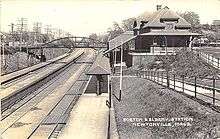
A red brick station was constructed slightly to the east in the 1870s, one of a small number of B&A stations built that decade.[6] It ultimately became the first stop outside Boston for long-distance trains on the Boston and Albany Railroad.[7][8] After Amtrak took over intercity service in 1971, the Bay State briefly stopped at Newtonville.[9]
The present station has one active side platform next to the southern track (Turnpike side); trains on the far track can be boarded by standing on the near track on a wooden crossing, as is occasionally done when the southern track is closed for repairs. A second platform, now abandoned, sits aside the northern track. Both platforms are low level.
Bus connections
Newtonville is served by one local MBTA Bus route on Walnut Street, and three express routes on Washington Street:
- 59 Needham Junction - Watertown Square via Newtonville
- 553 Roberts - Downtown Boston via Central Square, Waltham, Newtonville & Newton Corner
- 554 Waverly Square - Downtown Boston via Bentley College , Central Square, Waltham, Newtonville & Newton Corner
- 556 Waltham Highlands - Downtown Boston via Central Square, Waltham, Newtonville & Newton Corner
References
- 1 2 Fleishman, Thelma (1999). Images of America: Newton. Arcadia Publishing. p. 33. ISBN 9780738537740 – via Google Books.
- ↑ Burrows, F.W. (January 1909). "The Newtons". New England Magazine. 39 (5): 555.
- ↑ "Ridership and Service Statistics" (PDF) (14 ed.). Massachusetts Bay Transportation Authority. 2014. Retrieved 1 June 2014.
- ↑ Woodward, E.F.; Ward, W.F. (April 1848). "Map of the Town of Newton".
- ↑ "Part of Newtonville". Atlas of Newton. J.B. Beers & Co. 1874 – via Ward Maps.
- ↑ Ochsner, Jeffrey Karl (June 1988). "Architecture for the Boston & Albany Railroad: 1881-1894". Journal of the Society of Architectural Historians. 47 (2): 112, 120. doi:10.2307/990324. JSTOR 990324. (Subscription required (help)).
- ↑ "Newtonville Railroad Station. Boston & Albany Railroad sign. Newton, MA". 19 February 1956 – via Digital Commonwealth.
- ↑ "Boston and Albany" (PDF). New York Central Railroad. April 27, 1941. pp. 7–14.
- ↑ Nationwide Schedules of Intercity Passenger Service. Amtrak. January 16, 1972. p. 48 – via Museum of Railway Timetables.
External links
- MBTA - Newtonville

- Harvard Street entrance from Google Maps Street View
- Walnut Street entrance from Google Maps Street View