Newhope, Arkansas
| Newhope, Arkansas | |
|---|---|
| Unincorporated community | |
 Newhope, Arkansas  Newhope, Arkansas | |
| Coordinates: 34°13′49″N 93°52′49″W / 34.23028°N 93.88028°WCoordinates: 34°13′49″N 93°52′49″W / 34.23028°N 93.88028°W | |
| Country | United States |
| State | Arkansas |
| County | Pike |
| Elevation | 755 ft (230 m) |
| Time zone | UTC-6 (Central (CST)) |
| • Summer (DST) | UTC-5 (CDT) |
| ZIP code | 71959 |
| Area code(s) | 870 |
| GNIS feature ID | 77844[1] |
Newhope is an unincorporated community in Pike County, Arkansas, United States. Newhope is located at the junction of U.S. Route 70 and Arkansas Highway 369, 8 miles (13 km) west of Daisy. Newhope has a post office with ZIP code 71959.[2]
References
Municipalities and communities of Pike County, Arkansas, United States | ||
|---|---|---|
| Cities | 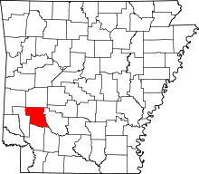 | |
| Towns | ||
| CDP | ||
| Unincorporated communities | ||
| Footnotes | ‡This populated place also has portions in an adjacent county or counties | |
This article is issued from
Wikipedia.
The text is licensed under Creative Commons - Attribution - Sharealike.
Additional terms may apply for the media files.