New Year Island (Northern Territory)
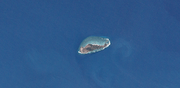 LANDSAT true color image of New Year Island Group, Northern Territory, Australia | |
|
New Year Island | |
| Geography | |
|---|---|
| Location | Arafura Sea |
| Coordinates | 10°54′29″S 133°01′52″E / 10.908°S 133.031°ECoordinates: 10°54′29″S 133°01′52″E / 10.908°S 133.031°E |
| Administration | |
|
Australia | |
| State | Northern Territory |
| Region | Top End |
New Year Island is an low-lying, uninhabited island in the Arafura Sea. It is part of the Northern Territory of Australia, and is 294 km north-east of Darwin, and 50 km east of Croker Island. It is approximately 2 km long, and 800 metres wide.[1]
Like all islands in the Croker Group, New Year Island is Aboriginal freehold land, held by the Arnhem Land Aboriginal Land Trust.[2]
New Year Island is noteworthy in that a small rock 60 metres to its north is the northernmost land in the Northern Territory.[3]
See also
References
- ↑ "Mapcarta". Retrieved May 22, 2016.
- ↑ "Northern Territory Government: Sites of Conservation Significance" (PDF). Retrieved May 23, 2016.
- ↑ "Celebrate New Years Eve All Over Australia". Retrieved August 8, 2017.
This article is issued from
Wikipedia.
The text is licensed under Creative Commons - Attribution - Sharealike.
Additional terms may apply for the media files.