Phetchaburi Road
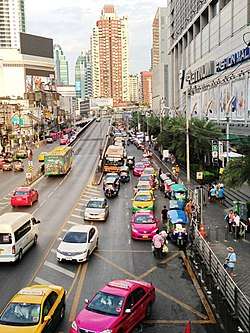

Phetchaburi Road (Thai: ถนนเพชรบุรี) is an one major road of Bangkok. It has a starting point at Yommarat Intersection near Yommarat Railway Halt and Uruphong Intersection to end at Khlong Tan Intersection passes through 4 districts viz Dusit, Ratchathewi, Huai Khwang and Suan Luang, the length is about 9 km (round about 5.5 mi).
The road runs through many important places such as Pratunam Intersection, Pantip Plaza, Platinum Fashion Mall, Embassy of The Republic of Indonesia, Tourism Authority of Thailand (TAT), Saint Dominic School etc.
It was built in July 1905 during the reign of King Chulalongkorn (Rama V) starting at the end of Ko Suea Road (ถนนคอเสื้อ; lit: collar road; today's Phitsanulok Road) go to the end at Pratunam, it was originally called "Pra Chae Chin Road" (ถนนประแจจีน; Chinese decorative design road) after the type of Chinese porcelain, one of the most popular collections in that era. Later on February 16, 1919, King Vajiravudh (Rama Vi) bestow on new name to Phetchaburi Road. The name honours one of members of the Thai royal family Valaya Alongkorn, Princess of Phetchaburi.
In 1962, the road was extended from Pratunam to the end of the Khlong Tan like today, officially opened in the following year. In this phase is often unofficially called "New Phetchaburi Road" (ถนนเพชรบุรีตัดใหม่).[1] [2]
On the night of September 24, 1990, a serious accident occurred in New Phetchaburi Road in the phase meeting Witthayu Road. A gas tank truck overturns resulting in an explosion of LPG, and caused a great fire. There were hundreds of casualties and deaths.[3]
See more
References
- ↑ สำนักงานเขตราชเทวี. "ถนนเพชรบุรี." [ออนไลน์]. เข้าถึงได้จาก : http://office.bangkok.go.th/ratchathewi/index.php?option=com_content&view=article&id=74:2012-06-03-00-52-09&catid=52:2012-06-03-00-50-50&Itemid=101 [ม.ป.ป.]. สืบค้น 30 มิถุนายน 2558. Thai: ภาษาไทย
- ↑ กนกวลี ชูชัยยะ. พจนานุกรมวิสามานยนามไทย : วัด วัง ถนน สะพาน ป้อม. พิมพ์ครั้งที่ 2. กรุงเทพมหานคร : ราชบัณฑิตยสถาน, 2548, หน้า . Thai: ภาษาไทย
- ↑ "LPG tanker accident revives memories of 1990". The Nation. 2012-03-24.
| Wikimedia Commons has media related to Phetchaburi Road. |
Coordinates: 13°45′1.57″N 100°33′37.34″E / 13.7504361°N 100.5603722°E