New Jersey Route 413
| ||||
|---|---|---|---|---|
 | ||||
| Route information | ||||
| Maintained by Burlington County Bridge Commission and Burlington County | ||||
| Length | 0.76 mi[1] (1.22 km) | |||
| Existed | January 1, 1953[2] – present | |||
| Major junctions | ||||
| West end |
| |||
| East end |
| |||
| Location | ||||
| Counties | Burlington | |||
| Highway system | ||||
| ||||

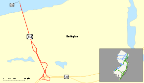
Route 413 is a 0.76-mile-long (1.22 km) state highway located entirely in the City of Burlington, New Jersey, United States. It is an eastward extension into New Jersey of the longer Pennsylvania Route 413 (PA 413). The western terminus in the middle of the Burlington–Bristol Bridge crossing of the Delaware River at the New Jersey–Pennsylvania state border; the eastern terminus is at an intersection with U.S. Route 130 (US 130). Despite the east–west orientation, Route 413 runs north–south, but PA 413 is signed north–south. Prior to the 1953 renumbering, Route 413 was Route S25, a prefixed spur of Route 25.
Route description

Route 413 begins at the state line, midway along the Burlington–Bristol Bridge, as a continuation of PA 413. As the road descends from the bridge, a toll booth spans the width of the road though a toll is only collected for westbound traffic. The highway heads southward, heading along Keim Boulevard, and becomes maintained by Burlington County. For eastbound traffic, a right-in/right-out intersection with Veterans Drive is present while for westbound traffic, an exit for Reed Street is located before the toll booths. South of here, an oblong traffic circle, bisected by NJ Transit's River Line light rail, is found and has intersections with West Broad Street.[3]
South of here, the Route 413 continues as a divided highway with one lane in each direction passing through an area of commercial businesses. The road comes to another oblong traffic circle, with intersections at Oakland Avenue, Washington Avenue, and Lincoln Avenue. One house and two businesses are located along the eastern edge of the circle. South of this circle, Route 413 ends at a complex intersection with US 130 (on which County Route 543 runs concurrently), Taylor Avenue, Salem Road, and Mott Avenue.[3]
History
.svg.png)

In the 1927 renumbering of highways in New Jersey, US 130 was assigned as a part of New Jersey State Highway Route 25, which made up US 1 and US 9 as well. During that renumbering in 1927, Route 413 was originally New Jersey State Highway Route S-25, a prefixed spur of State Highway Route 25. The highway remained intact along its alignment in Keim Road to the Burlington–Bristol Bridge until January 1, 1953.[4]
On January 1, 1953, the New Jersey State Highway Department performed a second renumbering of state highways. State Highway Route 25, which had run at the southern terminus with Route 130, was decommissioned for the sole designation. Since State Highway Route 25 was decommissioned, State Highway Route S-25 would be orphaned and was decommissioned that day. The Highway Department renumbered S-25's alignment to Route 413, which continued as PA 413.[5]
Major intersections
The entire route is in Burlington County.
| Location | mi[1] | km | Destinations | Notes | |
|---|---|---|---|---|---|
| Delaware River | 0.00 | 0.00 | Pennsylvania state line | ||
| Burlington-Bristol Bridge (Westbound toll, cash or E-ZPass) | |||||
| Burlington | 0.76 | 1.22 | |||
1.000 mi = 1.609 km; 1.000 km = 0.621 mi
| |||||
See also

References
- 1 2 "New Jersey Route 413 straight line diagram" (PDF). New Jersey Department of Transportation. 2008. Retrieved 2009-03-09.
- ↑ "New Route Markers Go Up Next Month" (PDF). The Hackettstown Gazette. December 18, 1952. p. 17. Retrieved September 26, 2018.
- 1 2 Google (February 20, 2017). "Overview of Route 413" (Map). Google Maps. Google. Retrieved February 20, 2017.
- ↑ State of New Jersey, Laws of 1927, Chapter 319.
- ↑ "1953 renumbering". New Jersey Department of Highways. Archived from the original on June 28, 2011. Retrieved July 31, 2009.
External links
Route map:

- Alps's Roads - NJ 413 images