New Jersey Route 172
| ||||
|---|---|---|---|---|
| George Street | ||||
 | ||||
| Route information | ||||
| Maintained by NJDOT | ||||
| Length | 0.81 mi[1] (1.30 km) | |||
| Existed | 1955 – present | |||
| Major junctions | ||||
| West end |
Commercial Avenue in New Brunswick (continues as | |||
| East end |
| |||
| Location | ||||
| Counties | Middlesex | |||
| Highway system | ||||
| ||||

Route 172 is a short state highway in New Brunswick, New Jersey, United States. The designation runs along the southernmost leg of George Street, which is county and city-maintained the rest of the way. Route 172 is 0.81 miles (1.30 km) long, serving as a connector from an interchange with Route 18 to an intersection with County Route 527. The highway was assigned in the 1950s, when nearby Route 18 was realigned onto a new freeway over Burnet Street in New Brunswick. Route 172 underwent a major upgrade during the reconstruction of Route 18, including a roundabout at an intersection with CR 617, and a brand-new interchange with the local lanes of Route 18.
Route description
_at_Commercial_Avenue_and_Middlesex_County_Route_672_in_New_Brunswick%2C_Middlesex_County%2C_New_Jersey.jpg)
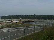
Route 172 begins at an interchange with the local lanes of Route 18 in the city of New Brunswick. The highway heads northward and passes through the Douglass Campus of Rutgers University. Route 172 then intersects with a local road, which serves the purposes of the university. The highway then progresses towards County Route 617 (CR 617; Ryders Lane), which heads southward from a roundabout with Route 172. Route 172 then turns to the west along George Street. After the roundabout, the highway intersects with Nichol Avenue and Route 172 continues into downtown New Brunswick. There, the highway intersects with Bishop Street, and terminates at an intersection with Commercial Avenue and CR 527 continues along George Street, the right-of-way.[1]
History
Route 172 originated as alignment of State Highway Route S-28, which was assigned in the 1927 state highway renumbering.[2] In the 1953 renumbering, State Highway Route S-28 was reassigned as Route 18.[3] However, just a few years after the designation of NJ 18 in New Brunswick along George Street, construction of a bypass around New Brunswick began. The highway was constructed along Burnet Street, which became state-maintained by the State Highway Department. The route was completed to Route 27, and Route 18 was moved onto that alignment. The former alignment of Route 18 remained state-maintained up to the intersection with Commercial Avenue, which was eventually re-designated as Route 172.[4]
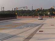
When the New Jersey Department of Transportation started construction on upgrading the bypass, the fly-over ramp and on-ramp to and from Route 172 were torn down for construction of a new interchange along a new local/express format. The overpass was closed on October 12, 2007 to begin the construction.[5] The bridge was built by 1955[4] and was replaced in 2008.[6] On January 2, 2009, the new exit ramp for Route 18 to Route 172 was reopened to traffic.[7]
Major intersections
The entire route is in New Brunswick, Middlesex County.
| mi[1] | km | Destinations | Notes | ||
|---|---|---|---|---|---|
| 0.00 | 0.00 | ||||
| 0.81 | 1.30 | ||||
| 1.000 mi = 1.609 km; 1.000 km = 0.621 mi | |||||
See also


- New Jersey Route 171
References
- 1 2 3 New Jersey Department of Transportation. "Route 172 straight line diagram" (PDF). Retrieved 2007-03-26.
- ↑ ROUTE NO. S-28. Beginning at Route No. 28 in Borough of Middlesex, thence via Raritan Avenue and River Road to Route No. 27 Highland Park, thence via Route No. 27 to New Brunswick, thence via Weston's Mills, Tanners Corner, Old Bridge and Browntown to Route No. 4 in Matawan. L. 1927, c. 319
- ↑ 1953 renumbering, New Jersey Department of Highways, archived from the original on June 28, 2011, retrieved July 31, 2009
- 1 2 Kolva, Jeanne. Highland Park In The 20th Century. Mount Pleasant, SC: Arcadia Publishing. p. 68. ISBN 9780738597683.
- ↑ "Route 18 Reconstruction - Traffic Alerts". New Jersey Department of Transportation. 2009. Retrieved 2009-02-05.
- ↑ "Route 18 Reconstruction Overview". New Jersey Department of Transportation. 2009. Retrieved 2009-02-05.
- ↑ "NJDOT to open Route 18 ramp to George Street in New Brunswick". New Jersey Department of Transportation. January 2, 2009. Retrieved 2009-02-05.
External links
Route map:

- New Jersey Highway Ends: Route 172
- Speed Limits for State Roads: Route 172