New Inn
| New Inn | |
|---|---|
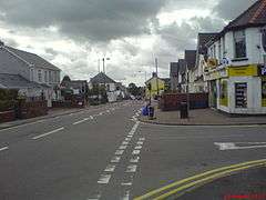 The Highway and junction with New Road. Looking south towards Berry's Corner | |
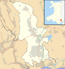 New Inn New Inn shown within Torfaen | |
| Area | 11.44 km2 (4.42 sq mi) [1] |
| Population | 5,986 (2011)[2] |
| • Density | 523/km2 (1,350/sq mi) |
| OS grid reference | ST 300 999 |
| Community |
|
| Principal area | |
| Ceremonial county | |
| Country | Wales |
| Sovereign state | United Kingdom |
| Post town | PONTYPOOL |
| Postcode district | NP4 |
| Dialling code | 01495 |
| Police | Gwent |
| Fire | South Wales |
| Ambulance | Welsh |
| EU Parliament | Wales |
| UK Parliament | |
| Welsh Assembly | |
New Inn is a village and community of approximately 3,000 households directly south east of Pontypool, within the County Borough of Torfaen in Wales, within the historic boundaries of Monmouthshire.
Location
The village is bounded to the north by the Monmouthshire & Brecon Canal; on the east by the Torfaen and Monmouthshire administrative border; the western boundary follows the Afon Lwyd river between Pontypool Park Gates and Chapel Lane in Pontrhydyrun.[3] The southern boundary is difficult to accurately determine but probably extends no further than the Pimlico Garage on the old Newport Road.
History
The modern-day village grew from a small number of houses built during the very late nineteenth century and into the twentieth century along The Highway (the main road through the village), which was then the main route between Newport (to the south) and Pontypool. The development of Panteg steelworks and a large marshalling yard and building of Pontypool Road Station further allowed the village to expand. By 1910 the village's population was around 800.
The initial housing along The Highway was added to during several phases. Residential housing was built around the Ruth Road and Coed-y-Canddo areas containing predominantly 1930s-style housing accommodating more prosperous railway workers. Council housing was built in the 1950s on Caroline Road and adjacent roads as well as in the lower New Inn area (known as the Lancaster Road estate). Of interest are the still-standing prefabricated homes built shortly after the Second World War along The Walk. Further post-war developments included the 'Heol Felin' housing estate (all roads begin Heol (Welsh for road)) built throughout the 1960s and into the early 1970s. The Golf Road development followed from the late 1960s into the 1970s and grew further with additional developments in the 1980s. The more recent development has seen the former Walker Steel industrial area (which itself had been built on what was known as the Admiralty sidings) between the railway and the canal was developed into the Coed Camlas housing estate.
The village is now bypassed by the A4042. This dual carriageway provides rapid access to rest of Torfaen, Newport, Cardiff and to Bristol via the M4 corridor.
Amenities
St. Mary’s Church, Panteg is the local Church in Wales church which is nestled a little way from the village centre to the south east. New Inn Congregational Church meet in the Chapel building at the south end of the village. Also at the south end of the village is Panteg Methodist Church. The village contains St Mary's Church Hall (1930), the New Inn Chapel Hall, New Inn Community Hall (previously Panteg Public Hall) shops and small convenience stores along The Highway.
Two public houses (The Teazer and Lower New Inn) operate and Greenlawn (Social) Club. New Inn's central post office closed in 2016; a small sub-post office operates in the local Spa.
A football pitch (where New Inn AFC play) and changing rooms, tennis courts as well as a children’s play area are clustered near the centre of New Inn. Jarrold's Field, off New Road is a large recreational space with several rugby and football pitches: home to New Panteg RFC and the New Inn Junior and Youth Football Clubs.
The former New Inn infants’ school has been renovated into a family learning centre. The main local school is New Inn Primary School for 4 – 11 year olds. It was formed by the amalgamation of Greenlawn Junior School and New Inn Infants' School in 2006.
Its fire station serves Pontypool, Griffithstown, Sebastopol and New Inn, and the surrounding villages of Little Mill and Penperlleni.[4]
The village is close to the southernmost reach of the Brecon Beacons National Park.[5] Immediately east of part of the village is Llandegfedd Reservoir, popular for surface water sports such as wind-surfing and coarse fishing.
Railway
A reduction in size of the railway station took place in the mid 20th century; the current form has a platform for trains travelling south to Cwmbran and one for travel north to Abergavenny and beyond. It was renamed Pontypool & New Inn station in 1994.
Gallery of New Inn photographs
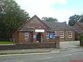 St Mary's Panteg Church Hall
 New Inn Community Hall (previously Panteg Public Hall)
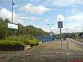
Nearby areas
Districts closest to New Inn | |
|---|---|
Demographic indicators
All data from 2001 Census.[6]
Total population of 6,349 (Torfaen 90,949). 48.5% Male, 51.5% Female (Torfaen - 48.4% Male, 51.6% Female). Age Structure: 18.8% aged between 0-15, 34.5% aged between 16-44, 25.9% aged 45–59/64 and 20.8% of pensionable age.
- Socio-Economic Indicators
Activity Rates (2001) Male (16-74) economic activity rate 71.1% (Torfaen 67.8%, Wales 67.7%), female (16-74) economic activity rate 60.3% (Torfaen 54.2%, Wales 54.5%), total economic activity rate 65.6% (Torfaen 60.8%, Wales 61.0%).
- Unemployment (2004)
37 people registered unemployed, 19 males and 18 females (June 2004). Of the 37 claimants, 5 are under 24 years of age. There is no-one registered as long term unemployed (unemployed for over 52 weeks).
- Home Ownership (2001)
New Inn has a higher proportion of owner occupied households at 82.3% than Torfaen 68.3% and Wales as a whole 71.3%. 9.2% of properties are rented from the local authority (Torfaen 22.8%, Wales 13.7%)
- Car Ownership (2001)
16.6% of households in New Inn do not own a car (Torfaen 27.2%, Wales 26.0%).
- Education (2001)
Residents qualified to Level 4/5: 20.1% (Torfaen 13.6%, Wales 17.4%). (Level 4/5: First degree, Higher degree, NVQ levels 4 and 5, HNC, HND, Qualified Teacher status, Qualified Medical Doctor, Qualified Dentist, Qualified Nurse, Midwife, Health Visitor)
- Lone Parent Families (2001)
6.8% of all households in New Inn are occupied by lone parents (Torfaen 10.8%, Wales 10.6%).
Trivia
New Inn appears as the first property on the Welsh version of Monopoly. The company Biffa is also displayed on the same square.
Edward Thomas Chapman VC is buried in Panteg cemetery, New Inn.
Railways
Pontypool & New Inn station is on the Welsh Marches Line.
References
- ↑ "2011 Census:Quick Statistics:Population Density for New Inn". Office for National Statistics. Retrieved 29 Nov 2013.
- ↑ "2011 Census:Key Statistics:Key Figures for New Inn". Office for National Statistics. Retrieved 25 Nov 2013.
- ↑ Ordnance Survey. Newport and Pontypool / Casnewydd a Pont-y-Pwl (OS Explorer Map Active). Ordnance Survey, Nov 2006. ISBN 0-319-46350-8
- ↑ http://www.southwales-fire.gov.uk/SWFSCMS/WhereWeAre/stations/newinn.htm South Wales Fire Service
- ↑ http://www.breconbeacons.org/livemap
- ↑ http://www.torfaen.gov.uk/CommunityAndLiving/YourLocalArea/NewInn.aspx 2001 Census Data
External links
- New Inn Chapel
- New Inn Community Hall
- New Inn Community Website
- New Inn Fire Station
- Pontypool Past & Present - Pontypool's only community website!
| Principal settlements | 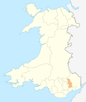 | |
|---|---|---|
| Electoral wards | ||
| Communities | ||
| Places of interest | ||
| Rivers and canals | ||
| Topics | ||