Nevada State Route 399
| ||||
|---|---|---|---|---|
| Eagle Picher Mine Road, Pitt Road | ||||
| Route information | ||||
| Maintained by NDOT | ||||
| Length | 18.184 mi[1] (29.264 km) | |||
| Existed | 1976 – present | |||
| Major junctions | ||||
| West end | Eagle Picher Mine | |||
| East end |
| |||
| Location | ||||
| Counties | Pershing | |||
| Highway system | ||||
| ||||

State Route 399 (SR 399) is an 18.18-mile (29.26 km) state highway in Pershing County, Nevada. It connects Eagle-Picher Mine to Lovelock, the nearest town.
Route description
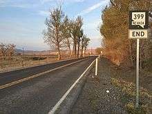
The east end of SR 399
SR 399's west terminus is at the entrance to Eagle-Picher Mine, which mines diatomite. SR 399 continues northeast and intersects Seven Troughs Road. SR 399 goes southwest on Seven Troughs Road until it meets SR 854, where it becomes Pitt Road. Pitt Road continues east until it meets North Meridian Road/SR 398 north of Lovelock.[2]
History
SR 399 was established on July 1, 1976.[3]
Major intersections
The entire route is in Pershing County.
| Location | mi | km | Destinations | Notes | |
|---|---|---|---|---|---|
| | 0 | 0.0 | Eagle-Picher Mine | Western terminus | |
| | |||||
| | Eastern terminus | ||||
| 1.000 mi = 1.609 km; 1.000 km = 0.621 mi | |||||
See also


References
| Wikimedia Commons has media related to Nevada State Route 399. |
Route map:
- ↑ Nevada Department of Transportation (January 2017). "State Maintained Highways of Nevada: Descriptions and Maps". Retrieved 2017-04-10.
- ↑ Google (June 14, 2015). "Overview of SR 399" (Map). Google Maps. Google.
- ↑ Nevada's State Maintained Highways: Descriptions, Index and Maps. Nevada Department of Transportation. January 2001.
This article is issued from
Wikipedia.
The text is licensed under Creative Commons - Attribution - Sharealike.
Additional terms may apply for the media files.