Innenstadt, Cologne
| Innenstadt | ||
|---|---|---|
| 1st District of Cologne | ||
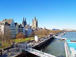 Rheingarten embankment; visible in the background are Cologne Cathedral (center left) and Groß St. Martin church (center) | ||
| ||
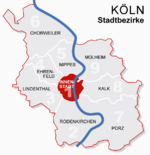 Location of Innenstadt shown in red | ||
| Country | Germany | |
| Federal state | North Rhine-Westphalia | |
| City | Cologne | |
| Area | ||
| • Total | 16.4 km2 (6.3 sq mi) | |
| Population (December 2016) | ||
| • Total | 128,295 | |
| • Density | 7,838/km2 (20,300/sq mi) | |

.jpg)
Innenstadt (German: Köln-Innenstadt) is the central city district (Stadtbezirk) of the City of Cologne in Germany.
The district was established with the last communal land reform in 1975, and comprises Cologne's historic old town (Altstadt), the Gründerzeit era new town (Neustadt) plus the right-Rhenish district of Deutz. Innenstadt has about 127,000 inhabitants (as of December 2008) and covers an area of 16.4 square kilometres.
Subdivisions
Innenstadt is made up of five Stadtteile (city parts):
| # | City part | Population (2016) | Area (km²) | Pop. per km² | map |
|---|---|---|---|---|---|
| 101 | Altstadt-Süd | 27,580 | 2,36 | 11,681 | 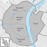 |
| 102 | Neustadt-Süd | 38,467 | 2,82 | 13,624 | |
| 103 | Altstadt-Nord | 18,307 | 2,46 | 7,454 | |
| 104 | Neustadt-Nord | 28,478 | 3,49 | 8,162 | |
| 105 | Deutz | 15,463 | 5,24 | 2,951 | |
| source: Kölner Stadtteilinformation 2016 (in German) | |||||
Landmarks
Among the landmarks in Innenstadt are Cologne Cathedral, the twelve romanesque churches of Cologne[1] (St. Andreas, St. Aposteln, St. Cäcilien, St. Georg, St. Gereon, St. Kunibert, St. Maria im Kapitol, St. Maria Lyskirchen, Groß St. Martin, St. Pantaleon, St. Severin and St. Ursula) and the 14th century Cologne City Hall (Kölner Rathaus). Several high rise structures were built over the last years as landmarks for Veedel (city quarters) within the district, most notably KölnTurm at MediaPark and the three Kranhaus buildings at Rheinauhafen.
Transportation
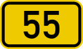
As the business center of Cologne, the Innenstadt is well served by numerous railway stations and highway. The largest train station is Köln Hauptbahnhof, other stations include Köln Messe/Deutz, Köln Hansaring, Köln West and Köln Süd station, as well as a dense net of Cologne Stadtbahn tram and U-Bahn stations. The Cologne Ring (Kölner Ringe) is a city boulevard, encircling the old town of Cologne. It is part of Bundesstraße 55 and picks up several principal arterial roads, which lead into adjacent city districts.
Rhine bridges


- Deutzer Brücke
See also
References
- ↑ http://www.romanische-kirchen-koeln.de/ueberuns.html Förderverein Romanische Kirchen Köln e.V. (in German)
External links
| Wikimedia Commons has media related to Köln-Innenstadt. |
- Official webpage of the district (in German)
| ||