Kalk, Cologne
| Kalk | |
|---|---|
| 8th District of Cologne | |
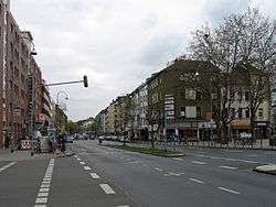 Kalker Hauptstraße | |
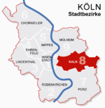 Location of Kalk shown in red | |
| Country | Germany |
| Federal state | North Rhine-Westphalia |
| City | Cologne (Köln) |
| Area | |
| • Total | 38.2 km2 (14.7 sq mi) |
| Population (December 2009) | |
| • Total | 109,045 |
| • Density | 2,852/km2 (7,390/sq mi) |

Kalk (German: Köln-Kalk [ˈkœln ˈkalk], Ripuarian: Kallek [ˈkalək] or [kalːk]) is the Eighth city district or Stadtbezirk of Cologne, Germany. Kalk was merged into the city of Cologne in 1910, the district was formed in 1975.
The district of Kalk borders with Mülheim to the North, Rheinisch-Bergischer Kreis to the East, the Cologne borough of Porz to the South and Deutz to the West.
Subdivisions
Kalk consists of nine Stadtteile (city parts):
| # | City part | Population (2009) | Area (km²) | Pop. per km² | map |
|---|---|---|---|---|---|
| 801 | Humboldt/Gremberg | 14,835 | 2,82 | 5,258 |  |
| 802 | Kalk | 21,192 | 2,97 | 7,128 | |
| 803 | Vingst | 11,558 | 1,12 | 10,315 | |
| 804 | Höhenberg | 11,936 | 2,20 | 5,436 | |
| 805 | Ostheim | 10,720 | 3,75 | 2,862 | |
| 806 | Merheim | 9,540 | 3,81 | 2,507 | |
| 807 | Brück | 9,734 | 7,51 | 1,297 | |
| 808 | Rath/Heumar | 10,957 | 13,1 | 837 | |
| 909 | Neubrück | 8,573 | 1,10 | 7,806 | |
| source: Die Kölner Stadtteile in Zahlen 2010 (in German) | |||||
Education
The Kaiserin-Theophanu-Schule is located in Kalk.[1]
The Japanische Schule Köln e.V. (ケルン日本語補習授業校 Kerun Nihongo Hoshū Jugyō Kō), a Japanese weekend school, holds its classes in the Kaiserin-Theophanu-Schule. It began holding classes there as of 20 August 2009.[2]
Transportation
Kalk is served by numerous railway stations and highways. Train stations include Köln-Trimbornstraße and numerous light rail stations of Cologne Stadtbahn line 1 and 9. The Bundesautobahn 3 and 4 connect Kalk with the Cologne Beltway.
References
- ↑ Home page. Kaiserin-Theophanu-Schule. Retrieved on April 6, 2015. "Kaiserin-Theophanu-Schule Kantstrasse 3 51103 Köln-Kalk"
- ↑ "Geschichte Archived 27 July 2013 at the Wayback Machine.." Japanische Schule Köln. Retrieved on February 14, 2015. "Wir sind umgezogen. Ab 20.08.2009 findet der Unterricht in der Kaiserin-Theophanu-Schule, Kantstr. 3 in 51103 Köln-Kalk statt." Japanese version Archived 14 February 2015 at the Wayback Machine..
External links
| Wikimedia Commons has media related to Köln-Kalk (Stadtbezirk). |
- Official webpage of the district (in German)
Coordinates: 50°56′09″N 7°01′07″E / 50.9358°N 7.0186°E
| ||