Neudrossenfeld
| Neudrossenfeld | ||
|---|---|---|
| ||
 Neudrossenfeld Location of Neudrossenfeld within Kulmbach district 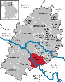 | ||
| Coordinates: 50°1′N 11°30′E / 50.017°N 11.500°ECoordinates: 50°1′N 11°30′E / 50.017°N 11.500°E | ||
| Country | Germany | |
| State | Bavaria | |
| Admin. region | Oberfranken | |
| District | Kulmbach | |
| Government | ||
| • Mayor | Dieter Schaar | |
| Area | ||
| • Total | 50.24 km2 (19.40 sq mi) | |
| Elevation | 334 m (1,096 ft) | |
| Population (2017-12-31)[1] | ||
| • Total | 3,757 | |
| • Density | 75/km2 (190/sq mi) | |
| Time zone | CET/CEST (UTC+1/+2) | |
| Postal codes | 95512 | |
| Dialling codes | 09203 | |
| Vehicle registration | KU | |
| Website | www.neudrossenfeld.de | |

Neudrossenfeld is a municipality in the district of Kulmbach in Bavaria in Germany.
City arrangement
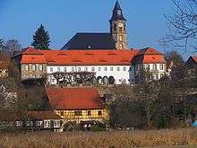
Church, castle and mill

Old bridge over Roter Main river
Neudrossenfeld is arranged in the following boroughs:
|
|
|
Sport
The towns association football club TSV Neudrossenfeld, formed in 1924, celebrated its greatest success in 2014 when it won promotion to the northern division of the Bayernliga for the first time.
References
- ↑ "Fortschreibung des Bevölkerungsstandes". Bayerisches Landesamt für Statistik und Datenverarbeitung (in German). September 2018.
Towns and municipalities in Kulmbach | ||
|---|---|---|
This article is issued from
Wikipedia.
The text is licensed under Creative Commons - Attribution - Sharealike.
Additional terms may apply for the media files.