Neimar
| Neimar Неимар | |
|---|---|
| Urban neighbourhood | |
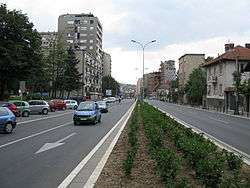 South Boulevard, Neimar to the right | |
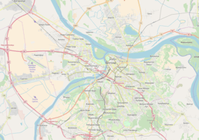 Neimar Location within Belgrade | |
| Coordinates: 44°47′40″N 20°28′18″E / 44.794511°N 20.471625°ECoordinates: 44°47′40″N 20°28′18″E / 44.794511°N 20.471625°E | |
| Country |
|
| Region | Belgrade |
| Municipality | Vračar |
| Time zone | UTC+1 (CET) |
| • Summer (DST) | UTC+2 (CEST) |
| Postal code | 11050 |
| Area code | +381(0)11 |
| Car plates | BG |
Neimar (Serbian: Неимар) is an urban neighborhood of Belgrade, the capital of Serbia. It is located in Belgrade's municipality of Vračar.
Name
The settlement was originally named Kotež Neimar.[1] Kotež is a Serbian rendering of the French cottage, a suburban settlement of individual residential houses.[2] Neimar was the name of the construction society on whose land the neighborhood was built. The word itself, neimar, means a builder or mason, and entered Serbian language via Turkish from the Arabic mi'mar.
Location
Neimar is located 2 km (1.2 mi) south-east of downtown Belgrade, in the south-western corner of the municipality. It occupies the south-eastern slope of the Vračar hill, which descends to the former valleys of the creeks of Mokroluški potok (now a highway) and Čuburski potok (now a South Boulevard). It borders the neighborhoods of Vračar on the north, Čubura on the north-east (sub-neighborhood of Gradić Pejton) and east, Autokomanda on the south while on the west it leans on the Karađorđev Park.[3][4]
History
Uninhabited slope from Čubura to the Čuburski potok valley (modern South Boulevard) was included into the city's construction plans in 1906. At that time, it was occupied by the fields, orchards and vineyards, mostly belonging to the merchant Panta Tadić. First regulatory plan, which included proposed streets layout, is from 1907 and the land was parceled in 1908. It envisioned an irregular street plan, two squares and a park in the south-east part. Construction company "Neimar" was founded in 1919 and in 1920 they purchased the land from Tadić. Original plans for the neighborhood were made in 1921 by the Viennese architects Emil Hoppe, Otto Schönthal and Marcel Kammerer, all pupils of Otto Wagner. After several disagreements with the city administration, the plan was finally approved on 12 June 1924.[1]
Characteristics
Neimar is entirely a residential area. The neighborhood is bounded by some of the most important streets for city's transportation, like the Boulevard of the Liberation (west), South Boulevard and the highway (including the Autokomanda interchange, both south) but itself represents a web of short, narrow streets. Until the 1990s the neighborhood managed to preserve its old architecture (mostly short buildings and family houses with yards), but since then several blocks of modern complexes with higher buildings have been constructed.
The local community of Neimar existed until the late 2000s, when the municipality of Vračar abolished local communities. In the 1990s, adjoining local community of France Rozman was annexed to Neimar. Population of Neimar in that period was 8,205 (14,493 with France Rozman) in 1981,[5] 7,186 (12,800) in 1991[6] and 12,058 in 2002.[7]
Cathedral of the Assumption of Mary
The street of Hadži Milentijava in Neimar is the location of the Cathedral of the Blessed Virgin Mary. A group of French business people settled in the area in the early 1920s. Their children were taught by the Assumptionist nuns and the monks built the church in 1924-25, which was colloquially called the "French church" by the local population. The church was consecrated by Angelo Roncalli, at the time Holy See's official to Bulgaria, and the future pope John XXIII. In 1930, the monumental belfry was erected, consisting of three bells: the largest was donation of the king Alexander I of Yugoslavia, middle one was sent from the Vatican and the smallest one was purchased from the donation of the adherents. In 1938 the Assumptionists began building a new church, envisioned as the memorial church for the French and Serbian soldiers killed in the World War I, with the addition of the clergy house and the monastery. Due to the outbreak of the World War II, the new church remained unfinished and after the war new Communist authorities basically commandeered it. It was used as the storage unit for the factories but, due to the good acoustics, it was used by the Radio Belgrade for taping the music shows. Facing the diminished interest among the younger generations to serve in the church, the Assumptionists left in 1982. Catholics took over the church and after almost 50 years continued the construction of the church in 1987. The new church was consecrated and declared a cathedral in 1988. The monastery and the adjoining auxiliary edifices were transformed into the Home of the Saint John of Capistrano. New monumental pipe organ was installed in 2000.[8][9]
The interior of the new church was painted in the mixed Catholic-Orthodox manner, sometimes described as the result of the "picturesque illustration of the confusing encounter of the East and West in Belgrade". Virgin Mary was presented in both traditions, in the Orthodox one in the lower section and in the Western Marian iconography in the upper section. She is surrounded by both the Catholic and Orthodox saints, including the father of the Serbian church, Saint Sava. Remaining from the French Assumptionists, there is a Gallic rooster on the cross above the old belfry. Saint John of Capistrano, whose name bears the monastery, was chosen because of his participation in the successful defense of the city during the 1456 Siege of Belgrade. He personally commanded the detachment consisting of the Crusaders and strongly pushed for the all-European Crusade against the Ottoman Turks.[8][9]
Municipality
When Belgrade was administratively divided into the municipalities in 1952, Neimar became one of the city's municipalities, with the population of 28,885 by the 1953 census.[10] On 1 January 1957 it merged with the municipality of Istočni Vračar and part of the municipality of Terazije to create the modern municipality of Vračar.
References
- 1 2 Zlata Vukasnović Macura. "Sećanje Plan Emila Hopea i Ota Šentala za Kotež Neimar" (in Serbian; summary in English).
- ↑ "Značenje reči Kotež" (in Serbian). Štaznači.com.
- ↑ Beograd - plan i vodič. Geokarta. 1999. ISBN 86-459-0006-8.
- ↑ Beograd - plan grada. M@gic M@p. 2006. ISBN 86-83501-53-1.
- ↑ Osnovni skupovi stanovništva u zemlji – SFRJ, SR i SAP, opštine i mesne zajednice 31.03.1981, tabela 191. Savezni zavod za statistiku (txt file). 1983.
- ↑ Stanovništvo prema migracionim obeležjima – SFRJ, SR i SAP, opštine i mesne zajednice 31.03.1991, tabela 018. Savezni zavod za statistiku (txt file). 1983.
- ↑ Popis stanovništva po mesnim zajednicama, Saopštenje 40/2002, page 4. Zavod za informatiku i statistiku grada Beograda. 26 July 2002.
- 1 2 Milan Četnik (18 February 2012), "Sveti Sava ispod galskog petal", Politika (in Serbian)
- 1 2 "Župa Blažene Djevice Marije – katedrala Beogradske nadbiskupije" (in Serbian). Roman Catholic Archdiocese of Belgrade. 2014.
- ↑ Popis stanovništva 1953, Stanovništvo po narodnosti (pdf). Savezni zavod za statistiku, Beograd.