Negernbötel
| Negernbötel | ||
|---|---|---|
| ||
 Negernbötel Location of Negernbötel within Segeberg district 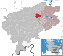  | ||
| Coordinates: 53°59′4″N 10°15′1″E / 53.98444°N 10.25028°ECoordinates: 53°59′4″N 10°15′1″E / 53.98444°N 10.25028°E | ||
| Country | Germany | |
| State | Schleswig-Holstein | |
| District | Segeberg | |
| Municipal assoc. | Trave-Land | |
| Government | ||
| • Mayor | Dieter Beuk | |
| Area | ||
| • Total | 16.97 km2 (6.55 sq mi) | |
| Elevation | 41 m (135 ft) | |
| Population (2016-12-31)[1] | ||
| • Total | 997 | |
| • Density | 59/km2 (150/sq mi) | |
| Time zone | CET/CEST (UTC+1/+2) | |
| Postal codes | 23795 | |
| Dialling codes | 04328, 04551 | |
| Vehicle registration | SE | |
| Website |
www.amt-trave- land.de | |

Negernbötel is a municipality in the district of Segeberg, in Schleswig-Holstein, Germany.
References
| Authority control |
|---|
This article is issued from
Wikipedia.
The text is licensed under Creative Commons - Attribution - Sharealike.
Additional terms may apply for the media files.