Dasher, Georgia
| Dasher, Georgia | |
|---|---|
| Town | |
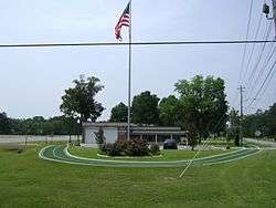 Dasher City Hall and Fire Department | |
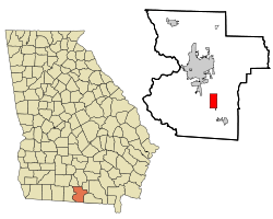 Location in Lowndes County and the state of Georgia | |
| Coordinates: 30°44′43″N 83°13′23″W / 30.74528°N 83.22306°WCoordinates: 30°44′43″N 83°13′23″W / 30.74528°N 83.22306°W | |
| Country | United States |
| State | Georgia |
| County | Lowndes |
| Area | |
| • Total | 5 sq mi (12.8 km2) |
| • Land | 4.9 sq mi (12.6 km2) |
| • Water | 0.1 sq mi (0.2 km2) |
| Elevation | 180 ft (55 m) |
| Population (2010) | |
| • Total | 912 |
| • Estimate (2016)[1] | 979 |
| • Density | 169/sq mi (65.2/km2) |
| Time zone | UTC-5 (Eastern (EST)) |
| • Summer (DST) | UTC-4 (EDT) |
| ZIP code | 31601 |
| Area code(s) | 229 |
| FIPS code | 13-21744[2] |
| GNIS feature ID | 0313320[3] |
Dasher is a town in Lowndes County, Georgia, United States. The population was 834 at the 2000 census.
History
The Georgia General Assembly incorporated Dasher in 1968.[4] Dasher was founded ca. 1912, and named after O. P. Dasher, a pioneer citizen.[5]
Geography
Dasher is located at 30°44′43″N 83°13′23″W / 30.74528°N 83.22306°W (30.745391, -83.222919).[6]
According to the United States Census Bureau, the town has a total area of 4.9 square miles (13 km2), of which 4.9 square miles (13 km2) is land and 0.1 square miles (0.26 km2) (1.82%) is water.
Demographics
| Historical population | |||
|---|---|---|---|
| Census | Pop. | %± | |
| 2000 | 834 | — | |
| 2010 | 912 | 9.4% | |
| Est. 2016 | 979 | [1] | 7.3% |
| U.S. Decennial Census[7] | |||
As of the census[2] of 2000, there were 834 people, 298 households, and 230 families residing in the town. The population density was 171.7 people per square mile (66.3/km²). There were 322 housing units at an average density of 66.3 per square mile (25.6/km²). The racial makeup of the town was 93.65% White, 2.64% African American, 0.96% Native American, 0.96% Asian, 0.12% Pacific Islander, 0.36% from other races, and 1.32% from two or more races. Hispanic or Latino of any race were 2.28% of the population.
There were 298 households out of which 35.6% had children under the age of 18 living with them, 65.4% were married couples living together, 7.4% had a female householder with no husband present, and 22.5% were non-families. 19.5% of all households were made up of individuals and 8.7% had someone living alone who was 65 years of age or older. The average household size was 2.70 and the average family size was 3.11.
In the town, the population was spread out with 29.0% under the age of 18, 7.3% from 18 to 24, 25.7% from 25 to 44, 26.9% from 45 to 64, and 11.2% who were 65 years of age or older. The median age was 37 years. For every 100 females, there were 96.7 males. For every 100 females age 18 and over, there were 97.3 males.
The median income for a household in the town was $46,563, and the median income for a family was $53,750. Males had a median income of $34,375 versus $21,591 for females. The per capita income for the town was $18,168. About 3.4% of families and 6.1% of the population were below the poverty line, including 8.0% of those under age 18 and 5.4% of those age 65 or over.
References
- 1 2 "Population and Housing Unit Estimates". Retrieved June 9, 2017.
- 1 2 "American FactFinder". United States Census Bureau. Archived from the original on 2013-09-11. Retrieved 2008-01-31.
- ↑ "US Board on Geographic Names". United States Geological Survey. 2007-10-25. Retrieved 2008-01-31.
- ↑ "Dasher". GeorgiaGov. Retrieved 17 April 2018.
- ↑ Krakow, Kenneth K. (1975). Georgia Place-Names: Their History and Origins (PDF). Macon, GA: Winship Press. p. 59. ISBN 0-915430-00-2.
- ↑ "US Gazetteer files: 2010, 2000, and 1990". United States Census Bureau. 2011-02-12. Retrieved 2011-04-23.
- ↑ "Census of Population and Housing". Census.gov. Archived from the original on May 12, 2015. Retrieved June 4, 2015.
Municipalities and communities of Lowndes County, Georgia, United States | ||
|---|---|---|
| Cities | 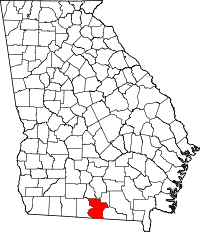 | |
| Town | ||
| CDP | ||
| Unincorporated communities | ||