Nawnghkio Township
| Nawnghkio Township နောင်ချိုမြို့နယ် | |
|---|---|
| Township | |
 Nawnghkio Township နောင်ချိုမြို့နယ် | |
| Coordinates: 22°20′02″N 96°48′05″E / 22.333809°N 96.801421°ECoordinates: 22°20′02″N 96°48′05″E / 22.333809°N 96.801421°E | |
| Country |
|
| Division | Shan State |
| District | Kyaukme |
| Township | Nawnghkio |
| Capital | Nawnghkio |
| Area | |
| • Total | 488.44 sq mi (1,265.06 km2) |
| Elevation | 2,750 ft (840 m) |
| Population | 126,143 |
| Time zone | UTC+6:30 (MST) |
Nawnghkio Township is a township of Kyaukme District in the Shan State of eastern Burma. The principal town and administrative seat is Nawnghkio. The name 'Nawnghkio' was started to call after a camp near a green lake (Shan language: nawng = lake or natural pond, hkio = green). The lake is located in the west of 'Haw Taw Monastery' of today's Nawnghkio.[1]
Geography
The township lies between 22° 45' and 23° 15' north latitude and 96° 00' and 97° 00' east longitude. Altitude ranges from 700 feet above the sea level in the lowest to 4300 feet in the highest with an average of 2750 feet. Occupying nearly half of the center of the land is highly productive plane surrounded by mountains in north, east, south and west. Mountains of the southern region are the highest. More than half of the surface area is covered by rain forests. Average number of raining days range from 90 to 130 days per year and annual rail fall varies from 47 to 70 inches. Thunder storms struck the area in the rainy season (May to October). Being in the temperate zone, the temperature varies from 43°-81 °F in the cold season to 61°-96 °F in the hot season. Many small rivers and streams are running across the township throughout the year forming, in some places, beautiful waterfalls. Inn Wine waterfall, Namngo waterfall, Inn Hpo waterfall, Chaunggyi Yay Pyan Taung waterfall and Thabyedoe waterfalls are famous. A hot water spring can be seen near Seik Hpu village. Thirty small dams are constructed for irrigation. Small scale hydroelectric power is used in many places.[1]
Borders
Nawnghkio Township is bordered[2] by:
- Thabeikkyin Township and Mogok Township to the north,
- Kyaukme Township to the northeast and east,
- Lawksawk Township to the south and
- Singu Township, Madaya Township, Pyinoolwin Township and Kyaukse Township to the west and southwest.[1]
Towns and villages
Thonze town is the administrative seat of the township in the past. On 28/April/1899, at the same time the Goteik viaduct (bridge) was started to be built across the Gokteik gorge near Nawnghkio, the seat moved to Nawnghkio. On 10/August/1961, Nawnghkio Farm Council was founded. According to official announcement letter from the Ministry of Internal Affairs dated 21/June/1972, Nawnghkio Township was organized with the following 6 wards and 35 village tracts of 249 villages:[1]
- Nawnghkio Myoma Group of 6 wards: Zay, Bhu Tar, Taung, Par Hat, Thapyay Yay, Nar Shao
- Kone Sam village tract
- Long Yone village tract
- Ngoke Ka Lay village tract
- Long Wei village tract
- Mak Hki Nu village tract
- Nyan Taw village tract
- Kan Gyi village tract
- Shwe Moke Htaw village tract
- Taung Shey village tract(Taung Kham)
- Yae Twin Gyi village tract
- Nawng Taw village tract
- Inn Hpo village tract
- Me Poke village tract
- Thone Se village tract
- Hsam Ma Hse village tract
- Ong Ma Hkar village tract
- Pin Tee village tract
- Bant Bway village tract
- Kone Gyi Ywar Ma village tract
- Kyein Ga Naing village tract
- Ah Nauk Kyu Inn village tract
- Nyaung Tauk village tract
- Hko Ong village tract
- Kone Thar village tract
- Seik Hpu village tract
- Ku Lar Kwe village tract
- Doe Pin village tract
- Kyauk Gyi village tract
- Bant Bway Kyin village tract
- Ho Hko (North) village tract
- Hsi Hson village tract
- Kone Gyi village tract
- Than Bo village tract
- Tha Yet Kone village tract
- Ah Htet Kyu Inn village tract
Geology
Myanmar’s biggest earthquake, measuring 8.2 on the Richter scale, took place in 1912 along the Kyauk Kyan Fault in northern Shan State, another of the country’s main faults (the first is the Sagaing Fault and the third is the Rakhine Fault).[3] Kyaukkyan fault is one of the prominent seismotectonic feature (Lat. 22˚ 18´N – Long. 96˚ 44´E). The large earthquake of 23 May 1912 (8.0 RM) with many foreshocks and aftershocks, seems to be associated with that fault.[4] It runs nearly north-south direction. Kyauk Kyan fault is 800 kilometres long, stretching from Shan State to southern Kayah State.[3][5][6][7]
Ethnic Groups, Language and Religion
Major ethnic groups are Shan and Danu which make more than 80% of township population. Other ethnic groups are Bamar, Gurkha, Indian, Kachin, Chin, Karen, Rakhine, Palaung, Lahu, Kokant, Chinese and Kayah. Myanmar is the official language and is used by most of the population. Shan is another commonest language in use. Buddhism is the main religion (97%). Christian, Hindu and Muslim are less common religions.[8] About one-third (33%) total township population are under 18 years of age.
Economy
- Agriculture is the major economy of the township (43% of township population). Rice, corn and sugarcane are main crops grown in the township. Other choices farmers are wheat, peanut, beans, sunflower, sesame, potato, flowers, coffee, damson, tea, orange, lichee, Macadamia and rubber.
- Agriculture based industry, timber extraction, charcoal production, burnt lime production, apiculture (bee keeping), and animal husbandry are other economies.
- People trade in "Every-Fifth-Day-Markets", which are famous trading places in Shan State, situated in Nawnghkio, Kangyi, Tawnghkam, Ban Bwe, Hsumhsai, Thonse, Hokho and Thayetkon villages. Annual pagoda festivals are also popular trading places. People also trade in brokers' sales centers. Nawnghkio Myanma Economic Bank is the only banking service of the township.[1]
- Mining is another famous economy of the township. Yadanar Theigi Mine in the north most part of the township is famous. Other smaller mines are also functional. Mines in the township are productive of various kinds of metals.
Special Places
- Gokteik bridge
- Innpho Swamp situated near Innma village in Hokho village tract
- Innwine and Namp Ngo Waterfalls near Innwine village and Yay Pyan Taung Waterfall near Changgyi village in Seeson village tract.
- Seikhpu Hot spring
- Ancient stupas and temples: in Thonze, Myin Phyu, Thaphankaing, Shweku-letpan, Chaungtha (Hokho village tract) and Namlinkhan village
- "Saya San Cave" situated 3 kilometers southeast of Hokho village where the leader of the Burmese peasant revolt of 1930-1931 and the leader of the first concerted effort to forcefully resist British domination, Saya San, and his followers spent their last days.
- Convict camps (labor camp or prison farm or penal colony)
Gallery
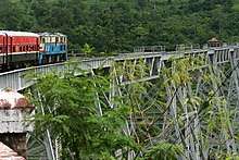 Goteik viaduct
 Changgyi waterfall
 Innwine waterfall
.jpg) Innwine waterfall
Innwine waterfall
Notes
- 1 2 3 4 5 []Nawnghkio Township Profile 2009, Township Peace and Development Council
- ↑ "Myanmar States/Divisions & Townships Overview Map" Myanmar Information Management Unit (MIMU)
- 1 2 The Myanmar Times, vol 22, No 433, news, Sagaing Fault surveyed to prepare for future quakes, by Nilar Win
- ↑ DEPARTMENT OF GEOLOGICAL ENGINEERING, FACULTY OF ENGINEERING, Gadjah Mada University, Report On Regional Geology of Myanmar, by Dr Ir. Subagyo Pramumijoyo, Kyaw Linn Zaw and Kyaw Zin Lat, page 13, IV. Structural Geology of Myanmar
- ↑
- ↑ Myanmar Action Plan on Disaster Risk Reduction (MAPDRR), August 2009, Page 2
- ↑ Acta Geoscientica Sinica, Vol.30 Supp.1: 1-3, Sep. 2009, Recognition of Paleo-Tethys Suture Zone in eastern Myanmar by Hla Hla AUNG, Myanmar Earthquake Committee, MES Building, Hlaing University Campus, Hlaing Township, Yangon, Myanmar
- ↑ Nawnghkio Township Profile 2009, Township Peace and Development Council
External links
- "Nawnghkio Google Satellite Map" map of administrative area with listing of principal settlements, from Maplandia
- "Nawnghkio Township - Shan State" Myanmar Information Management Unit (MIMU)
Capital: | |
|