Naunspitze
| Naunspitze | |
|---|---|
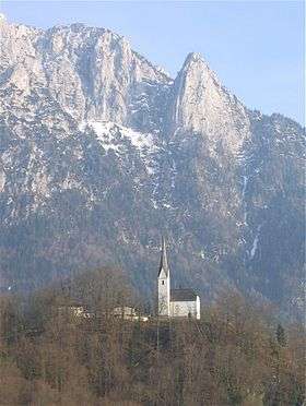 Church of St. Nicholas in Ebbs, with the Naunspitze (right) | |
| Highest point | |
| Elevation | 1,633 m (AA) (5,358 ft) |
| Coordinates | 47°36′00″N 12°14′00″E / 47.6°N 12.23333°ECoordinates: 47°36′00″N 12°14′00″E / 47.6°N 12.23333°E |
| Geography | |
| Parent range | Zahmer Kaiser |

The Naunspitze is a 1,633-metre-high peak in the Zahmer Kaiser, the northern ridge of the Kaisergebirge mountains in Tyrol, Austria. Seen from the west it is the first independent summit on the main crest. To the south it falls sharply away and, to the north, ends abruptly in a steep rock face that towers over the Inn valley near Ebbs. The next peak along the main ridge to the east is the Petersköpfl (1745m), which is separated from the Naunspitze by a small wind gap.
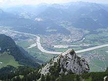
View from Petersköpfl over the Naunspitze, to Kiefersfelden way down in the Inn valley
Ascents
The Naunspitze may be reached without difficulty in about 45 minutes from the Vorderkaiserfelden Hut to the southwest, or in 20 minutes from the Petersköpfl. Several Alpine climbing routes lead up the rock faces to the north and west classified by the UIAA as grade III.
This article is issued from
Wikipedia.
The text is licensed under Creative Commons - Attribution - Sharealike.
Additional terms may apply for the media files.