Vorderkaiserfelden Hut
| Vorderkaiserfelden Hut | |
|---|---|
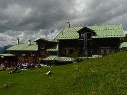 The Vorderkaiserfelden Hut | |
 Vorderkaiserfelden Hut | |
| Coordinates | 47°36′21″N 12°14′21″E / 47.60583°N 12.23917°ECoordinates: 47°36′21″N 12°14′21″E / 47.60583°N 12.23917°E |
| Country | Austria |
| Elevation | 1,384 m (4,541 ft) AA |
| Administration | |
| Hut type | DAV Hut Category I |
| Owner | DAV Oberland branch (Munich) |
| Website |
www |
| Facilities | |
| Beds/Bunks | 30 |
| Mattresses | 50 |
| Opening times | Open all-year round, works holidays at Easter and in December |
| Footnotes | |
| Hut reference | DAV |
The Vorderkaiserfelden Hut (German: Vorderkaiserfeldenhütte) is an alpine hut in the Kufstein district, Austria. It is located at 1,384 metres (4,541 ft) on the southwest slope of the Zahmer Kaiser below the Naunspitze and high above the Kaisertal valley in the Kaisergebirge mountain range. It has a good view over the Inn valley and Kufstein and across to the Mangfall Mountains and the Wilder Kaiser.
The hut is managed by the German Alpine Club's Oberland section. It has 64 communal bunks, 31 beds, and a "suite" for a couple in love.
The Vorderkaiserfelden Hut is open year-round except three weeks in December and after Easter. It can be accessed from Kufstein, the hike takes about 2.5 hours, or from Ebbs, also within about 2.5 hours.
Already in 1889, a hut with 6 communal bunks and 14 beds existed.
Access
Approaches
Crossings
- Stripsenjochhaus (1,577 m) via Höhenweg, Hochalm and Feldalm saddle, duration: 4 hours
- Anton Karg Haus and Hans Berger Haus via the Hechleitenalm, easy, duration: 2 hours
Ascents
- Naunspitze (1,633 m), medium, duration: 45 minutes
- Petersköpfl (1,745 m), medium, duration: 1 hour
- Pyramidenspitze (1,998 m), via the Zahmer Kaiser plateau, medium, duration: 2.5 hours
- Pyramidenspitze (1,998 m), via Hinterkaiserfeldenalm, medium, duration: 2.5 hours
- Vordere Kesselschneid (2,002 m), via Höhenweg, Ochsweidkar cirque, medium, duration: 3 hours
- Route to the Zahmer Kaiser over the Pyramidenspitze with descent through the Winkelkar cirque to Durchholzen.
- various climbing routes on the Naunspitze, the Petersköpfl and the Steingrubenwand as well as the Heimköpfl climbing garden (Klettergarten).
Gallery
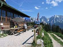
- The terrasse of the Vorderkaiserfelden Hut
 A little below the Vorderkaiserfelden Hut
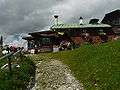 En route to the Vorderkaiserfelden Hut
External links
| Wikimedia Commons has media related to Vorderkaiserfeldenhuette. |
- Official website of Vorderkaiserfelden (in German)
- Website of the German Alpine Club (in German)
- Description by Cicerone (in English)
- Site of the Oberland Branch of the DAV (in German)