Naujan, Oriental Mindoro
| Naujan | ||
|---|---|---|
| Municipality | ||
| Municipality of Naujan | ||
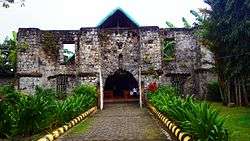 Naujan Church | ||
| ||
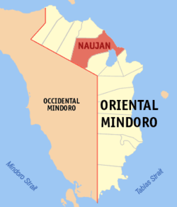 Map of Oriental Mindoro with Naujan highlighted | ||
.svg.png) Naujan Location within the Philippines | ||
| Coordinates: 13°19′N 121°18′E / 13.32°N 121.3°ECoordinates: 13°19′N 121°18′E / 13.32°N 121.3°E | ||
| Country |
| |
| Region | Mimaropa (Region IV-B) | |
| Province | Oriental Mindoro | |
| District | 1st district | |
| Founded | 1693 | |
| Incorporated | 1905 | |
| Barangays | 70 (see Barangays) | |
| Government [1] | ||
| • Type | Sangguniang Bayan | |
| • Mayor | Mark Navarro Marcos | |
| • Electorate | 54,205 voters (2016) | |
| Area [2] | ||
| • Total | 503.10 km2 (194.25 sq mi) | |
| Population (2015 census)[3] | ||
| • Total | 102,998 | |
| • Density | 200/km2 (530/sq mi) | |
| Time zone | UTC+8 (PST) | |
| ZIP code | 5204 | |
| PSGC | 175208000 | |
| IDD : area code | +63 (0)43 | |
| Climate type | Tropical climate | |
| Income class | 1st municipal income class | |
| Revenue (₱) | 233,898,767.05 (2016) | |
| Native languages |
Alangan Tagalog | |

Naujan, officially the Municipality of Naujan, is a 1st class municipality in the province of Oriental Mindoro, Philippines. According to the 2015 census, it has a population of 102,998 people.[3]
It assumed the status of a full-fledged municipality on January 4, 1905 under Act 1280. Its boundaries were permanently established in 1919.
Geography
It covers a land area of 50,310 hectares (124,300 acres), making it the largest municipality in the province and accounting for 12% of the province’s total land area. Naujan is 26 kilometres (16 mi) from Calapan.
Barangays
Naujan is politically subdivided into 72 barangays.
| Barangay | Population (2016) |
|---|---|
| Adrialuna | 1,997 |
| Andres Ilagan (Mag-asawang Tubig) | 606 |
| Antipolo | 518 |
| Apitong | 2,592 |
| Arangin | 1,031 |
| Aurora | 3,351 |
| Bacungan | 1,470 |
| Bagong Buhay | 2,089 |
| Balite | 993 |
| Bancuro | 2,001 |
| Banuton | 981 |
| Barcenaga | 4,709 |
| Bayani | 1,989 |
| Buhangin | 1,114 |
| Caburo | 291 |
| Concepcion | 879 |
| Dao | 1,385 |
| Del Pilar | 2,221 |
| Estrella | 2,567 |
| Evangelista | 3,070 |
| Gamao | 991 |
| General Esco | 1,312 |
| Herrera | 827 |
| Inarawan | 1,758 |
| Kalinisan | 1,351 |
| Laguna | 1,486 |
| Mabini | 586 |
| Magtibay | 562 |
| Mahabang Parang | 1,779 |
| Malalim Na Sapa | |
| Malaya | 1,186 |
| Malinao | 1,592 |
| Malvar | 1,469 |
| Masagana | 951 |
| Masaguing | 614 |
| Melgar A | 1,617 |
| Melgar B | 1,437 |
| Metolza | 708 |
| Montelago | 2,161 |
| Montemayor | 709 |
| Motoderazo | 1,866 |
| Mulawin | 1,322 |
| Nag-Iba I | 894 |
| Nag-Iba II | 1,498 |
| Pagkakaisa | 2,281 |
| Paitan | 1,519 |
| Paniquian | 1,602 |
| Pinagsabangan I | 2,305 |
| Pinagsabangan II | 2,419 |
| Piñahan | 1,256 |
| Poblacion I (Barangay I) | 801 |
| Poblacion II (Barangay II) | 687 |
| Poblacion III (Barangay III) | 917 |
| Putol | |
| Sampaguita | 2,482 |
| San Agustin I | 1,605 |
| San Agustin II | 1,655 |
| San Andres | 1,167 |
| San Antonio | 529 |
| San Carlos | 867 |
| San Isidro | |
| San Jose | 655 |
| San Luis | 930 |
| San Nicolas | 994 |
| San Pedro | 1,426 |
| Santa Cruz | 1,468 |
| Santa Isabel | 1,234 |
| Santa Maria | 3,158 |
| Santiago | 2,132 |
| Santo Niño | 1,633 |
| Tagumpay | 938 |
| Tigkan | 844 |
| Total | 102,998 |
Demographics
| Population census of Naujan | ||
|---|---|---|
| Year | Pop. | ±% p.a. |
| 1903 | 3,662 | — |
| 1918 | 9,139 | +6.29% |
| 1939 | 19,170 | +3.59% |
| 1948 | 22,382 | +1.74% |
| 1960 | 31,476 | +2.88% |
| 1970 | 45,685 | +3.79% |
| 1975 | 54,641 | +3.66% |
| 1980 | 61,216 | +2.30% |
| 1990 | 72,203 | +1.66% |
| 1995 | 75,726 | +0.90% |
| 2000 | 83,892 | +2.22% |
| 2007 | 90,629 | +1.07% |
| 2010 | 94,497 | +1.53% |
| 2015 | 102,998 | +1.65% |
| Source: Philippine Statistics Authority[3][4][5][6] | ||
Local government
2016-2019 Elected officials:
- Municipal Mayor: Atty. Mark N. Marcos
- Vice Mayor: Sheryl B. Morales
- Sangguniang Bayan Members:
- Marion Francis D. Marcos, Councilor
- Vilma D. Vargas, Councilor
- Jun S. Bugarin, Councilor
- Dein Z. Arago, Councilor
- Alexandra C. Casubuan, Councilor
- Daniel R. Arteza, Councilor
- Neil C. Bermudez, Councilor
- Deogracias U. Dela Paz, Councilor
- Engr. Ralph Jonnel Recto, ABC President
- Rogelio Banlugan, Councilor
See also
References
- ↑ "Municipality". Quezon City, Philippines: Department of the Interior and Local Government. Retrieved 31 May 2013.
- ↑ "Province: Oriental Mindoro". PSGC Interactive. Quezon City, Philippines: Philippine Statistics Authority. Retrieved 12 November 2016.
- 1 2 3 Census of Population (2015). "Region IV-B (Mimaropa)". Total Population by Province, City, Municipality and Barangay. PSA. Retrieved 20 June 2016.
- ↑ Census of Population and Housing (2010). "Region IV-B (Mimaropa)". Total Population by Province, City, Municipality and Barangay. NSO. Retrieved 29 June 2016.
- ↑ Censuses of Population (1903–2007). "Region IV-B (Mimaropa)". Table 1. Population Enumerated in Various Censuses by Province/Highly Urbanized City: 1903 to 2007. NSO.
- ↑ "Province of Oriental Mindoro". Municipality Population Data. Local Water Utilities Administration Research Division. Retrieved 17 December 2016.
External links
Places adjacent to Naujan, Oriental Mindoro | |
|---|---|
This article is issued from
Wikipedia.
The text is licensed under Creative Commons - Attribution - Sharealike.
Additional terms may apply for the media files.