National Register of Historic Places listings in Washington County, Georgia
This is a list of properties and districts in Washington County, Georgia that are listed on the National Register of Historic Places (NRHP).
- This National Park Service list is complete through NPS recent listings posted October 4, 2018.[1]
Current listings
| [2] | Name on the Register | Image | Date listed[3] | Location | City or town | Description |
|---|---|---|---|---|---|---|
| 1 | Church-Smith-Harris Street Historic District | December 31, 1987 (#87001268) |
E. Church, S. Smith, and S. Harris Sts. 32°58′44″N 82°48′29″W / 32.978889°N 82.808056°W |
Sandersville | ||
| 2 | City Cemetery | 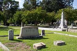 |
August 3, 1987 (#87001296) |
W. Church, Cemetery, and Haynes Sts. 32°58′57″N 82°48′55″W / 32.9825°N 82.815278°W |
Sandersville | |
| 3 | Thomas Jefferson Elder High and Industrial School | May 12, 1981 (#81000202) |
316 Hall St. 32°58′38″N 82°48′58″W / 32.97730°N 82.81605°W |
Sandersville | ||
| 4 | Forest Grove | January 26, 2005 (#04001556) |
1200 GA 242/Riddleville Rd. 32°57′51″N 82°47′25″W / 32.96416°N 82.79021°W |
Sandersville | library web page | |
| 5 | Francis Plantation | July 3, 1975 (#75000616) |
SE of Davisboro on SR 2189 (Josey Church Road?) 32°55′52″N 82°33′28″W / 32.931111°N 82.557778°W |
Davisboro | ||
| 6 | Holt Brothers Banking Company Building | 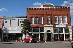 |
July 28, 1994 (#94000710) |
100-106 Malone St. 32°59′02″N 82°48′39″W / 32.98385°N 82.81092°W |
Sandersville | |
| 7 | James E. Johnson House | 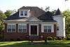 |
July 28, 1994 (#94000711) |
425 W. Church St. 32°58′54″N 82°49′03″W / 32.98155°N 82.81745°W |
Sandersville | |
| 8 | James Kelley House | July 28, 1994 (#94000712) |
Tennille-Harrison Rd. E of jct. with GA 15 32°55′53″N 82°48′01″W / 32.93130°N 82.80018°W |
Tennille | ||
| 9 | Charles Madden House | July 28, 1994 (#94000713) |
302 E. South Central St. 32°56′12″N 82°48′28″W / 32.93677°N 82.80790°W |
Tennille | ||
| 10 | North Harris Street Historic District | July 20, 1989 (#89000801) |
Roughly bounded by First Ave., Washington Ave., E. McCarty St., N. Harris St., Malone St., and Warthen St. 32°59′20″N 82°48′37″W / 32.988889°N 82.810278°W |
Sandersville | ||
| 11 | Sandersville Commercial and Industrial District | 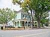 |
March 1, 2002 (#02000120) |
Roughly Jernigan, Gilmore, North Smith, East Haynes, W. Haynes, and Warthen Sts. 32°59′03″N 82°48′35″W / 32.984167°N 82.809722°W |
Sandersville | |
| 12 | Thomas W. Smith House | 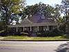 |
July 28, 1994 (#94000714) |
306 N. Main St. 32°56′21″N 82°48′38″W / 32.939141°N 82.81049°W |
Tennille | |
| 13 | Tennille Banking Company Building | 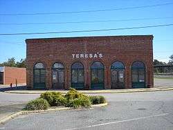 |
July 28, 1994 (#94000715) |
102-104 N. Main St. 32°56′11″N 82°48′41″W / 32.936389°N 82.811389°W |
Tennille | |
| 14 | Tennille Baptist Church | 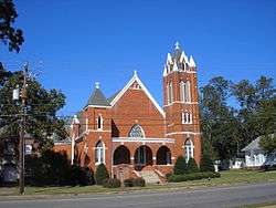 |
July 28, 1994 (#94000716) |
201-205 N. Main St. 32°56′20″N 82°48′41″W / 32.93876°N 82.81137°W |
Tennille | |
| 15 | Tennille Woman's Clubhouse | July 1, 1998 (#98000815) |
132 Smith St. 32°56′16″N 82°48′45″W / 32.93777°N 82.81259°W |
Tennille | ||
| 16 | Warthen Historic District | 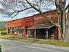 |
July 25, 1997 (#97000755) |
Jct. of GA 15, GA 102, Warthen St., Old Sadersville-Sparta and Walker Dairy Rds. 33°06′12″N 82°48′18″W / 33.103333°N 82.805°W |
Warthen | |
| 17 | Washington County Courthouse | 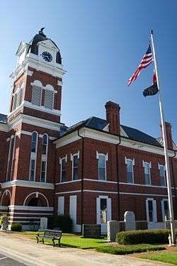 |
September 18, 1980 (#80001260) |
Courthouse Sq. 32°59′00″N 82°48′43″W / 32.983333°N 82.811944°W |
Sandersville | Is also in the Sandersville Commercial and Industrial District |
| 18 | Washington Manufacturing Company | July 28, 1994 (#94000717) |
Between E. Montgomery and Church Sts. at White Line St. 32°56′33″N 82°48′16″W / 32.94241°N 82.80443°W |
Tennille | Main building has been demolished | |
| 19 | Wrightsville and Tennille Railroad Company Building | 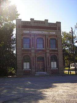 |
July 28, 1994 (#94000718) |
119 Central Ave. 32°56′06″N 82°48′46″W / 32.93500°N 82.81276°W |
Tennille |
References
- ↑ "National Register of Historic Places: Weekly List Actions". National Park Service, United States Department of the Interior. Retrieved on October 4, 2018.
- ↑ Numbers represent an ordering by significant words. Various colorings, defined here, differentiate National Historic Landmarks and historic districts from other NRHP buildings, structures, sites or objects.
- ↑ The eight-digit number below each date is the number assigned to each location in the National Register Information System database, which can be viewed by clicking the number.
| Wikimedia Commons has media related to National Register of Historic Places in Washington County, Georgia. |
This article is issued from
Wikipedia.
The text is licensed under Creative Commons - Attribution - Sharealike.
Additional terms may apply for the media files.