Warthen, Georgia
| Warthen, Georgia | |
|---|---|
| Unincorporated community | |
 Warthen, Georgia | |
| Coordinates: 33°06′08″N 82°48′13″W / 33.10222°N 82.80361°WCoordinates: 33°06′08″N 82°48′13″W / 33.10222°N 82.80361°W | |
| Country | United States |
| State | Georgia |
| County | Washington |
| Elevation | 479 ft (146 m) |
| Time zone | UTC-5 (Eastern (EST)) |
| • Summer (DST) | UTC-4 (EDT) |
| ZIP code | 31094 |
| Area code(s) | 478 |
| GNIS feature ID | 342360[1] |
Warthen is an unincorporated community in Washington County, Georgia, United States. The community is located at the junction of Georgia State Route 15 and Georgia State Route 102, 8.3 miles (13.4 km) north of Sandersville. Warthen has a post office with ZIP code 31094.[2][3] It was county seat of Washington County for a time in the 1780s.
See also
References
- ↑ "Warthen". Geographic Names Information System. United States Geological Survey.
- ↑ United States Postal Service. "USPS - Look Up a ZIP Code". Retrieved November 21, 2015.
- ↑ "Postmaster Finder - Post Offices by ZIP Code". United States Postal Service. Retrieved November 21, 2015.
Municipalities and communities of Washington County, Georgia, United States | ||
|---|---|---|
| Cities | 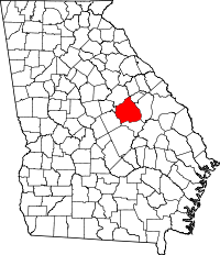 | |
| Towns | ||
| Unincorporated community | ||
This article is issued from
Wikipedia.
The text is licensed under Creative Commons - Attribution - Sharealike.
Additional terms may apply for the media files.