National Register of Historic Places listings in San Juan, Puerto Rico
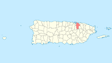
National Register entries listed below are found in San Juan municipality, highlighted here.
This portion of National Register of Historic Places listings in Puerto Rico covers the municipality of San Juan.
Names of places given are as appear in the National Register, reflecting name as given in NRHP application at the date of listing. Note, the National Register name system does not accommodate Spanish á, ñ and other letters.
- This National Park Service list is complete through NPS recent listings posted October 11, 2018.[1]
Current listings
| [2] | Name on the Register | Image | Date listed[3] | Location | Barrio | Description |
|---|---|---|---|---|---|---|
| 1 | Acueducto de San Juan | 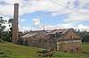 |
June 21, 2007 (#07000585) |
Flamboyán St. 18°23′21″N 66°03′32″W / 18.389163°N 66.058822°W |
El Cinco | From 1846. Rio Piedras filtration plant, etc. |
| 2 | Administration Building | October 26, 1983 (#83004195) |
University of the Sacred Heart campus, Rosales and San Antonio Sts. 18°26′33″N 66°03′32″W / 18.442535°N 66.058881°W |
Santurce | Also known as Portico and Chapel of the Sacred Heart University, a Classical Revival building from 1906 | |
| 3 | Antiguo Casino de Puerto Rico | 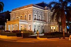 |
September 22, 1977 (#77001554) |
1 Ponce de León Ave. 18°27′58″N 66°06′41″W / 18.466130°N 66.111434°W |
San Juan Antiguo | Beaux Arts building from 1917 |
| 4 | Biblioteca Carnegie | .jpg) |
October 20, 1983 (#83004196) |
Ponce de León Ave., Puerta de Tierra 18°27′59″N 66°06′31″W / 18.466379°N 66.108550°W |
San Juan Antiguo | Classical Revival building from 1915 |
| 5 | Hiram Bithorn Municipal Stadium | 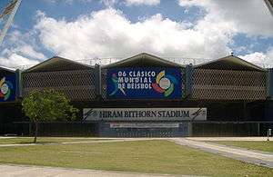 |
January 22, 2014 (#13001118) |
Franklin Delano Roosevelt Ave. 18°25′00″N 66°04′23″W / 18.416667°N 66.073056°W |
Hato Rey Norte | |
| 6 | El Capitolio de Puerto Rico | 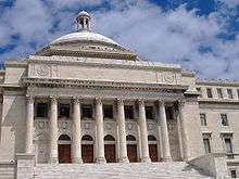 |
November 18, 1977 (#77001555) |
Ponce de León and Muñoz Rivera Avenues 18°28′00″N 66°06′21″W / 18.466752°N 66.105911°W |
San Juan Antiguo | The seat of government of Puerto Rico; a Classical Revival / Beaux Arts building from 1929, designed by Rafael Carmoega |
| 7 | Carcel de Puerta de Tierra[lower-alpha 1] | 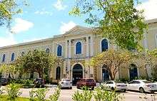 |
August 11, 1976 (#76002253) |
Ponce de León Ave., Stop 8, Puerta de Tierra 18°27′49″N 66°05′32″W / 18.463611°N 66.092279°W |
San Juan Antiguo | Spanish Neo-classical building from 1887[4] |
| 8 | Casa de España | 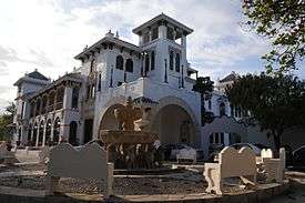 |
July 5, 1983 (#83002294) |
Ponce de León Ave. 18°27′59″N 66°06′29″W / 18.466432°N 66.108019°W |
San Juan Antiguo | Exotic / Moorish Revival house from 1932, designed by Pedro Adolfo de Castro |
| 9 | Casa Klumb |  |
November 14, 1997 (#97001307) |
1 Ramón B. López Ave. 18°23′58″N 66°02′06″W / 18.399506°N 66.034995°W |
Oriente | Modern Movement home from 1947 designed by Henry Klumb |
| 10 | Casa Dra. Concha Meléndez Ramírez | 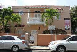 |
June 30, 2011 (#11000414) |
1400 Vilá Mayo St., at Manuel Rodríguez Serra St. 18°27′10″N 66°04′02″W / 18.452739°N 66.067317°W |
Santurce | |
| 11 | Casa Vigil | 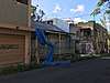 |
July 23, 2018 (#100002694) |
1018 Calle Ferrocarril 18°24′00″N 66°02′59″W / 18.399963°N 66.049708°W |
Pueblo | |
| 12 | Central High School | 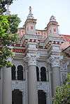 |
August 4, 1987 (#87001309) |
Ponce de León Ave. 18°26′53″N 66°04′11″W / 18.448092°N 66.069817°W |
Santurce | Spanish Renaissance style building from 1925 |
| 13 | Church of San Mateo de Cangrejos of Santurce | .jpg) |
January 2, 1985 (#85000044) |
Corner of San Jorge St. and Eduardo Conde Ave. 18°26′40″N 66°03′48″W / 18.444509°N 66.063428°W |
Santurce | 1832 church designed by Pedro Cobreros |
| 14 | Church, School, Convent and Parish House of San Agustín | 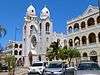 |
December 30, 1985 (#85003194) |
265 Ponce de León Ave. 18°27′56″N 66°05′56″W / 18.465565°N 66.098934°W |
San Juan Antiguo | From 1915 |
| 15 | Colegio de las Madres del Sagrado Corazón | 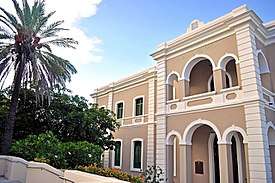 |
November 25, 1985 (#85002908) |
951 Ponce de León Ave. 18°27′16″N 66°04′46″W / 18.454338°N 66.079430°W |
Santurce | From 1880 |
| 16 | Condado Vanderbilt Hotel | 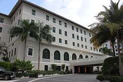 |
November 25, 2005 (#08001110) |
1055 Ashford Ave. 18°27′31″N 66°04′34″W / 18.458699°N 66.075997°W |
Santurce | Mission/Spanish Revival style hotel from 1919 |
| 17 | Distrito Histórico del Viejo San Juan – Old San Juan Historic District | 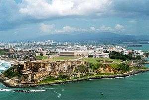 |
October 10, 1972 (#72001553) |
Northwest triangle of San Juan Islet; also roughly bounded by Muñoz Rivera and Ponce de León Avenues, Paseo de Covadonga, and J. A. Corretejer and Recinto Sur Streets 18°27′58″N 66°06′55″W / 18.466124°N 66.115383°W |
San Juan Antiguo | Second set of boundaries represents a boundary increase of July 30, 2012 |
| 18 | Edificio Aboy | September 28, 2001 (#01001069) |
603 Aboy St. 18°27′15″N 66°04′51″W / 18.454051°N 66.080857°W |
Santurce | Art Deco building from 1937, also known as Le Faro, designed by Jorge Julia Pasarell | |
| 19 | Edificio Comunidad de Orgullo Gay de Puerto Rico | 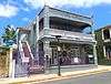 |
May 2, 2016 (#16000237) |
3 Saldaña St. 18°24′02″N 66°03′07″W / 18.400552°N 66.051890°W |
Pueblo | |
| 20 | Edificio del Valle |  |
November 20, 2004 (#04001243) |
1118 Ponce de León Ave. 18°27′04″N 66°04′31″W / 18.451199°N 66.075378°W |
Santurce | Mission/Spanish Revival building from 1941, designed by Rafael Carmoega Morales |
| 21 | Edificio Patio Español |  |
February 18, 2005 (#05000061) |
153 Cruz St. 18°27′57″N 66°06′58″W / 18.465927°N 66.116224°W |
San Juan Antiguo | Mission/Spanish Revival, Eclectic building from 1937, also known as La Filarmonica, designed by Eduardo Fossas López |
| 22 | Edificio Victory Garden |  |
October 13, 2004 (#04001149) |
1001 Ponce de León Ave., corner of Elisa Colberg St. 18°27′13″N 66°04′43″W / 18.453514°N 66.078582°W |
Santurce | Mission/Spanish Revival building from 1936, designed by Pedro Adolfo de Castro |
| 23 | Escuela Brambaugh |  |
May 5, 1989 (#89000324) |
San Juan Bautista St. and Ponce de León Ave. 18°27′55″N 66°05′44″W / 18.465266°N 66.095597°W |
San Juan Antiguo | From 1913, also known as Puerta de Tierra Public School |
| 24 | Escuela Graduado José Celso Barbosa | 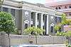 |
May 19, 1989 (#89000406) |
Ponce de León Ave. 18°27′57″N 66°06′04″W / 18.465928°N 66.101217°W |
San Juan Antiguo | Classical Revival style school from 1927 |
| 25 | El Falansterio de Puerta de Tierra | 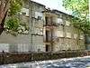 |
May 3, 1984 (#84003166) |
Bounded by railroad right-of-way, Fernández Juncos Avenue, and Matías Ledesma and San Juan Bautista Streets 18°27′48″N 66°05′47″W / 18.463390°N 66.096414°W |
San Juan Antiguo | Art Deco, from 1937 |
| 26 | Faro del Morro | .jpg) |
October 22, 1981 (#81000693) |
Summit of San Felipe del Morro Castle 18°28′16″N 66°07′25″W / 18.471053°N 66.123614°W |
San Juan Antiguo | Oldest lighthouse in Puerto Rico; this version lit in 1908 |
| 27 | Figueroa Apartments | September 14, 2000 (#00001124) |
601 Fernández Juncos Ave. 18°27′26″N 66°05′12″W / 18.457184°N 66.086744°W |
Santurce | Art Deco building by Armando Morales Cano, from 1935 | |
| 28 | La Fortaleza | 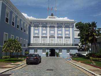 |
October 15, 1966 (#66000951) |
Between San Juan Bay and Recinto Oeste St., at Fortaleza St. 18°27′51″N 66°07′09″W / 18.464201°N 66.119294°W |
San Juan Antiguo | From 1533 |
| 29 | Fortín de San Gerónimo de Boquerón | 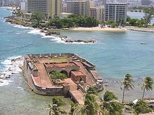 |
October 11, 1983 (#83004199) |
Puerta de Tierra 18°27′46″N 66°05′03″W / 18.462841°N 66.084199°W |
San Juan Antiguo | Building from 1791, also known as Museo de Historia Militar de Puerto Rico |
| 30 | La Giralda | 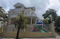 |
August 11, 2008 (#08000786) |
651 José Martí St. 18°27′19″N 66°05′07″W / 18.455288°N 66.085308°W |
Santurce | From 1910 |
| 31 | Gran Logia Espiritual Número 1 | 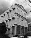 |
June 8, 2008 (#06000507) |
1612 Antonsanti St. 18°26′46″N 66°03′52″W / 18.446077°N 66.064383°W |
Santurce | Classical Revival building from 1910 |
| 32 | Hotel Normandie | 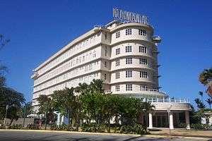 |
August 29, 1980 (#80004295) |
Ponce de León Ave. and San Gerónimo St. 18°27′52″N 66°05′15″W / 18.464493°N 66.087412°W |
San Juan Antiguo | Hotel that is a spectacular example of Streamline Moderne architecture, inspired by the Art Deco-style design of the ship SS Normandie |
| 33 | House at 659 Concordia Street |  |
October 18, 1991 (#91001501) |
659 Concordia St., Miramar 18°27′09″N 66°04′56″W / 18.452497°N 66.082298°W |
Santurce | Mission/Spanish Revival house from 1935, designed by Joseph O'Kelly |
| 34 | House at 659 La Paz Street | 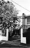 |
January 30, 1992 (#91002007) |
659 La Paz St., Miramar 18°27′10″N 66°04′58″W / 18.452857°N 66.082787°W |
Santurce | Mission/Spanish Revival house from 1928, designed by Pedro Adolfo de Castro |
| 35 | House at 663 La Paz Street | 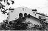 |
October 18, 1991 (#91001500) |
663 La Paz St., Miramar 18°27′09″N 66°04′58″W / 18.452633°N 66.082882°W |
Santurce | Another Mission/Spanish Revival house designed by Pedro Adolfo de Castro |
| 36 | House at 665 McKinley Street | 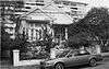 |
October 19, 1991 (#91001502) |
665 McKinley St., Miramar 18°27′19″N 66°05′02″W / 18.455259°N 66.083858°W |
Santurce | Vernacular Spanish Creole house from 1906 |
| 37 | Rafael M. Labra High School |  |
August 4, 1987 (#87001308) |
Ponce de León and Roberto H. Todd Aves. 18°27′00″N 66°04′28″W / 18.450072°N 66.074406°W |
Santurce | Georgian style school building from 1916 |
| 38 | Línea Avanzada | 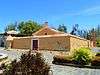 |
September 25, 1997 (#97001136) |
Eastern portion of the San Juan Islet 18°27′53″N 66°05′26″W / 18.464645°N 66.090544°W |
San Juan Antiguo | From 1797 |
| 39 | Miami Building | 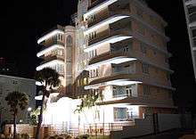 |
August 23, 1984 (#84003169) |
868 Ashford Ave. 18°27′37″N 66°04′50″W / 18.460336°N 66.080441°W |
Santurce | Art Deco building from 1936, designed by Pedro Menez |
| 40 | Luis Muñoz Rivera Park | 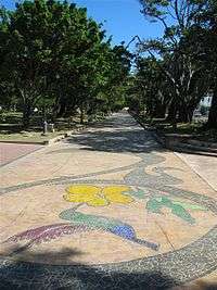 |
November 14, 2007 (#07001195) |
Ponce de León Ave., Stop 8, Puerta de Tierra 18°27′52″N 66°05′28″W / 18.464406°N 66.090986°W |
San Juan Antiguo | Park with Beaux Arts and Picturesque architecture and/or landscape design |
| 41 | Mural "La Familia" |  |
October 23, 2017 (#100001763) |
2030 Avenida Borinquen 18°26′15″N 66°03′18″W / 18.437530°N 66.055015°W |
Santurce | |
| 42 | General Norzagaray Bridge | .jpg) |
July 19, 1995 (#95000833) |
Highway 873, km 0.8, spanning the Quebrada Frailes 18°21′07″N 66°05′29″W / 18.351816°N 66.091420°W |
Caimito and Tortugo | Brick barrel vault bridge from 1855, known also as Puente de Los Frailes |
| 43 | Nuestra Señora de Lourdes Chapel | .jpg) |
September 27, 1984 (#84003171) |
Ponce de León and Miramar Aves. 18°27′23″N 66°05′07″W / 18.456394°N 66.085148°W |
Santurce | Neo-Gothic style chapel from 1908, designed by Antonin Nechodoma |
| 44 | Martín Peña Bridge | 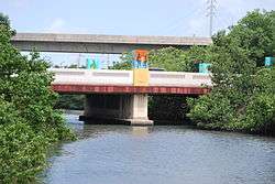 |
August 27, 2008 (#08000856) |
Highway 25, km 8 18°26′00″N 66°03′33″W / 18.433462°N 66.059045°W |
Santurce, Hato Rey Norte, and Hato Rey Central | Art Deco style bridge from 1939, designed by Cecilio Delgado and others (Try also Martín Peña Bridge ) |
| 45 | Polvorín de Miraflores | 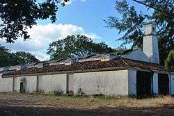 |
March 9, 1984 (#84003172) |
66 Aramania St., Old Miramar Naval Base 18°26′58″N 66°05′38″W / 18.449514°N 66.093904°W |
Santurce | A gunpowder magazine from 1776 |
| 46 | Puerto Rico Ilustrado – Edificio El Mundo | 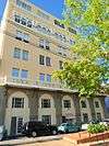 |
September 25, 1997 (#97001137) |
254 San José St. 18°27′51″N 66°07′01″W / 18.464067°N 66.117004°W |
San Juan Antiguo | From 1923 |
| 47 | Puerto Rico Island Penitentiary | 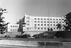 |
March 7, 2003 (#03000100) |
South of Highway 21 18°23′19″N 66°04′15″W / 18.388649°N 66.070756°W |
Monacillo Urbano | Built 1933, closed 2004, demolished 2015 |
| 48 | Residencia Aboy–Lompre | 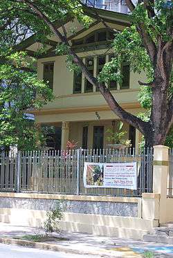 |
March 22, 1989 (#88001304) |
900 Ponce de León Ave. 18°27′16″N 66°04′51″W / 18.454349°N 66.080696°W |
Santurce | A Prairie School style house from 1919, designed by Antonin Nechodoma and others |
| 49 | Residencia de Señoritas Universidad de Puerto Rico; Río Piedras | .jpg) |
July 23, 2018 (#100002695) |
Near the intersection of Gándara and Barbosa Aves. 18°24′09″N 66°02′48″W / 18.402542°N 66.046776°W |
Universidad | |
| 50 | Residencia Luis Muñoz Marín |  |
September 29, 2011 (#11000712) |
Highway 877, km 0.4 18°23′12″N 66°01′42″W / 18.386667°N 66.028333°W |
Sabana Llana Sur | |
| 51 | Río Piedras Bridge | 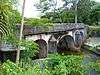 |
July 19, 1995 (#95000832) |
Highway 8839, km 12.5 18°23′40″N 66°03′21″W / 18.394386°N 66.055958°W |
El Cinco and Hato Rey Sur | A brick barrel vault bridge from 1853 |
| 52 | Rum Pilot Plant | July 26, 2010 (#10000501) |
Highway 1, University of Puerto Rico Agricultural Experiment Station 18°23′46″N 66°03′48″W / 18.396115°N 66.063393°W |
El Cinco | ||
| 53 | San Antonio Railroad Bridge | 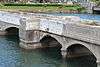 |
September 30, 2009 (#09000789) |
Spanning San Antonio Channel adjacent to Highway 1 at the east end of San Juan Islet 18°27′34″N 66°05′13″W / 18.459340°N 66.086891°W |
San Juan Antiguo and Santurce | |
| 54 | San Juan National Historic Site | October 15, 1966 (#66000930) |
Old San Juan[lower-alpha 2] 18°28′10″N 66°07′17″W / 18.469444°N 66.121389°W |
San Juan Antiguo | Dates from 1525 | |
| 55 | School of Tropical Medicine | 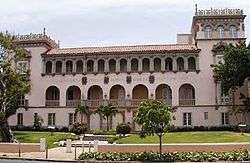 |
September 29, 1983 (#83002297) |
Ponce de León Ave., Puerta de Tierra 18°28′01″N 66°06′14″W / 18.467003°N 66.104005°W |
San Juan Antiguo | Neo-Plateresque building from 1920 |
| 56 | Superintendent of Lighthouses' Dwelling | .jpg) |
October 22, 1981 (#81000694) |
Coast Guard Station San Juan, La Puntilla 18°27′36″N 66°07′01″W / 18.460125°N 66.116874°W |
San Juan Antiguo | Hacienda style building from 1908 located inside the U.S Coast Guard base in La Puntilla |
| 57 | Supreme Court Building | 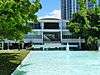 |
June 14, 2006 (#06000506) |
Luis Muñoz Rivera Park 18°27′47″N 66°05′18″W / 18.463189°N 66.088217°W |
San Juan Antiguo | Modern Movement building from 1955 |
| 58 | Templo del Maestro | 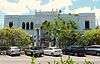 |
April 19, 2016 (#16000189) |
Constitución Ave., Stop 8 18°27′46″N 66°05′24″W / 18.462777°N 66.089976°W |
San Juan Antiguo | |
| 59 | U.S. Custom House |  |
February 10, 1988 (#88000075) |
1 Puntilla St. 18°27′46″N 66°06′56″W / 18.462822°N 66.115522°W |
San Juan Antiguo | 1924 building designed by Albert B. Nichols |
| 60 | U.S. Post Office and Courthouse | 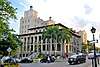 |
March 28, 1988 (#87000694) |
Block bounded by San Justo, Tanca, Commercio, and Recinto Sur Streets 18°27′50″N 66°06′53″W / 18.463839°N 66.114619°W |
San Juan Antiguo | From 1914, designed by Oscar Wenderoth |
| 61 | University of Puerto Rico Tower and Quadrangle | 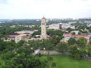 |
May 17, 1984 (#84003174) |
Ponce de León Ave. 18°24′10″N 66°02′59″W / 18.402705°N 66.049684°W |
Universidad | Tower and quadrangle from 1935, designed by Rafael Carmoega |
| 62 | Villa Victoria |  |
January 6, 2015 (#14001135) |
905 Ponce de León Ave. 18°27′16″N 66°04′48″W / 18.454554°N 66.080045°W |
Santurce |
See also
Notes
- ↑ The name of the Carcel de Puerta de Tierra is presented here without the accent on "Cárcel" in conformance with the usage in the building's National Register nomination form[4] and Federal Register announcement of listing.[5]
- ↑ The National Register listing for the San Juan National Historic Site includes components in both San Juan and Toa Baja municipalities.
References
- ↑ "National Register of Historic Places: Weekly List Actions". National Park Service, United States Department of the Interior. Retrieved on October 11, 2018.
- ↑ Numbers represent an ordering by significant words. Various colorings, defined here, differentiate National Historic Landmarks and historic districts from other NRHP buildings, structures, sites or objects.
- ↑ The eight-digit number below each date is the number assigned to each location in the National Register Information System database, which can be viewed by clicking the number.
- 1 2 Araoz, Gustavo F., Jr. (1976), National Register of Historic Places Inventory — Nomination Form: Carcel de Puerta de Tierra (PDF), retrieved February 12, 2018 .
- ↑ "Department of the Interior, Heritage Conservation and Recreation Service: National Register of Historic Places; Annual Listing of Historic Properties", 44 FR 7416 (February 6, 1979), at p. 7581.
External links
- Puerto Rico State Historic Preservation Office, National Register of Historic Places site
- National Park Service, National Register of Historic Places site

| ||
| Barrios | ||
This article is issued from
Wikipedia.
The text is licensed under Creative Commons - Attribution - Sharealike.
Additional terms may apply for the media files.