National Register of Historic Places listings in Chattooga County, Georgia

This is a list of properties and districts in Chattooga County, Georgia that are listed on the National Register of Historic Places (NRHP).

This National Park Service list is complete through NPS recent listings posted October 4, 2018.[1]
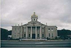
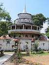
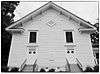
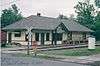
Current listings

[2] Name on the Register Image Date listed[3] Location City or town Description
1 Camp Juliette Low September 1, 1987
(#87001431)
GA 157
34°31′57″N 85°28′51″W / 34.5325°N 85.480833°W / 34.5325; -85.480833 (Camp Juliette Low)
Cloudland
2 Chattooga County Courthouse
Chattooga County Courthouse
September 18, 1980
(#80000988)
Courthouse Sq.
34°28′49″N 85°20′55″W / 34.480278°N 85.348611°W / 34.480278; -85.348611 (Chattooga County Courthouse)
Summerville
3 Georgia Site No. 9 CG 43 December 20, 1987
(#87002112)
Address Restricted
Summerville
4 Paradise Gardens
Paradise Gardens
March 27, 2012
(#12000166)
200 N. Lewis Street
34°30′47″N 85°19′00″W / 34.513174°N 85.316772°W / 34.513174; -85.316772 (Paradise Gardens)
Pennville
5 Penn Place September 29, 1988
(#88001828)
Penn Bridge Rd.
34°30′59″N 85°18′21″W / 34.516389°N 85.305833°W / 34.516389; -85.305833 (Penn Place)
Trion
6 Riegel Hospital February 20, 2002
(#02000079)
194 Allgood St.
34°32′31″N 85°18′46″W / 34.541944°N 85.312778°W / 34.541944; -85.312778 (Riegel Hospital)
Trion Demolished in 2010
7 Sardis Baptist Church
Sardis Baptist Church
August 21, 1997
(#97000862)
Junction of GA 114 and Sardis Church Rd.
34°21′09″N 85°26′37″W / 34.3525°N 85.443611°W / 34.3525; -85.443611 (Sardis Baptist Church)
Lyerly
8 Summerville Commercial Historic District May 16, 2012
(#12000280)
Centered around Commerce St., Georgia, & Washington Aves.
34°28′48″N 85°20′54″W / 34.480011°N 85.34832°W / 34.480011; -85.34832 (Summerville Commercial Historic District)
Summerville
9 Summerville Depot
Summerville Depot
January 29, 1992
(#91002037)
120 E. Washington Ave.
34°28′47″N 85°20′46″W / 34.479722°N 85.346111°W / 34.479722; -85.346111 (Summerville Depot)
Summerville

References

  1. "National Register of Historic Places: Weekly List Actions". National Park Service, United States Department of the Interior. Retrieved on October 4, 2018.
  2. Numbers represent an ordering by significant words. Various colorings, defined here, differentiate National Historic Landmarks and historic districts from other NRHP buildings, structures, sites or objects.
  3. The eight-digit number below each date is the number assigned to each location in the National Register Information System database, which can be viewed by clicking the number.
This article is issued from Wikipedia. The text is licensed under Creative Commons - Attribution - Sharealike. Additional terms may apply for the media files.