National Register of Historic Places listings in Beadle County, South Dakota
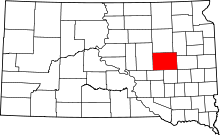
Location of Beadle County in South Dakota
This is a list of the National Register of Historic Places listings in Beadle County, South Dakota.
This is intended to be a complete list of the properties and districts on the National Register of Historic Places in Beadle County, South Dakota, United States. The locations of National Register properties and districts for which the latitude and longitude coordinates are included below, may be seen in a map.[1]
There are 25 properties and districts listed on the National Register in the county.
- This National Park Service list is complete through NPS recent listings posted October 11, 2018.[2]
Current listings
| [3] | Name on the Register[4] | Image | Date listed[5] | Location | City or town | Description |
|---|---|---|---|---|---|---|
| 1 | Anderson Barn | August 15, 2003 (#03000763) |
19411 394th Street 44°34′29″N 98°20′35″W / 44.574722°N 98.343056°W |
Hitchcock | ||
| 2 | Archeological Site No. 39BE3 |  |
August 6, 1993 (#93000802) |
Address Restricted |
Wolsey | |
| 3 | Faye Bowden-Agnus Saunders House |  |
December 2, 1998 (#98001401) |
669 Dakota Ave., N. 44°22′26″N 98°12′52″W / 44.373982°N 98.214495°W |
Huron | |
| 4 | Campbell Park Historic District of Huron | 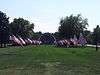 |
November 5, 1974 (#74001888) |
Roughly bounded by 5th, 7th, 9th, Wisconsin, California, Kansas, and Dakota Sts. Boundary decrease (listed March 27, 2012, refnum 12000269): Roughly bounded by 5th St. SW, 9th St. SW, Wisconsin Ave. SW and Oregon Ave. SE 44°21′16″N 98°12′49″W / 44.354444°N 98.213611°W |
Huron | |
| 5 | Chicago and North Western Roundhouse | 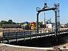 |
November 19, 1998 (#98001411) |
North of 1st St. 44°21′57″N 98°12′21″W / 44.365833°N 98.205833°W |
Huron | |
| 6 | Dairy Building | January 25, 1990 (#90001642) |
Off 3rd St. near the South Dakota State Fair Grounds 44°21′47″N 98°13′47″W / 44.363056°N 98.229722°W |
Huron | ||
| 7 | Hattie O. and Henry Drake Octagon House | 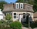 |
January 30, 1992 (#91002045) |
605 3rd St., SW. 44°21′49″N 98°13′26″W / 44.363611°N 98.223889°W |
Huron | |
| 8 | Grace Episcopal Church | 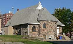 |
July 19, 1989 (#89000828) |
4th St. and Kansas Ave., SE. 44°21′43″N 98°12′46″W / 44.361819°N 98.212853°W |
Huron | |
| 9 | Margaret and Vernon Moxon House[6] | 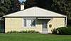 |
February 10, 1999 (#98001409) |
1305 McDonald St. 44°21′04″N 98°13′26″W / 44.351208°N 98.224018°W[8]) |
Huron | |
| 10 | McMonies Barn | July 28, 2004 (#04000762) |
604 33rd Street, S.E. 44°19′38″N 98°12′12″W / 44.327222°N 98.203333°W |
Huron | ||
| 11 | Milford Hutterite Colony | June 30, 1982 (#82003909) |
Northeast of Lake Byron 44°36′48″N 98°03′17″W / 44.613333°N 98.054722°W |
Carpenter | ||
| 12 | Old Riverside Hutterite Colony | June 30, 1982 (#82003910) |
Off the James River 44°28′12″N 96°52′52″W / 44.47°N 96.881111°W |
Huron | ||
| 13 | Albert S. Piper Homestead Claim Shanty | August 28, 1998 (#98001126) |
2 miles north of Lake Byron 44°36′01″N 98°08′35″W / 44.600278°N 98.143056°W |
Carpenter | ||
| 14 | Pyle House | 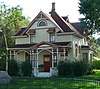 |
December 30, 1974 (#74002288) |
376 Idaho Avenue, S.E. 44°21′44″N 98°12′32″W / 44.362271°N 98.208773°W |
Huron | |
| 15 | Site 39BE2 | |
June 8, 2005 (#05000589) |
Address Restricted |
Wessington Springs | |
| 16 | Site 39BE14 | |
January 30, 1984 (#84003199) |
Address Restricted |
Huron | |
| 17 | Site 39BE15 | |
January 30, 1984 (#84003201) |
Address Restricted |
Huron | |
| 18 | Site 39BE23 | |
January 30, 1984 (#84003206) |
Address Restricted |
Huron | |
| 19 | Site 39BE46 | |
January 30, 1984 (#84003208) |
Address Restricted |
Huron | |
| 20 | Site 39BE48 | |
January 30, 1984 (#84003210) |
Address Restricted |
Huron | |
| 21 | Site 39BE57 | |
January 30, 1984 (#84003212) |
Address Restricted |
Yale | |
| 22 | Site 39BE64 | |
January 30, 1984 (#84003215) |
Address Restricted |
Yale | |
| 23 | South Dakota Dept. of Transportation Bridge No. 03-020-008 | December 9, 1993 (#93001260) |
Local road over unnamed creek 44°37′15″N 98°39′56″W / 44.620833°N 98.665556°W |
Wessington | ||
| 24 | South Dakota Dept. of Transportation Bridge No. 03-327-230 | December 9, 1993 (#93001261) |
Local road over Pearl Creek 44°17′49″N 98°02′24″W / 44.296944°N 98.04°W |
Cavour | ||
| 25 | South Dakota Dept. of Transportation Bridge No. 03-338-100 | December 9, 1993 (#93001269) |
Local road over Shue Creek 44°29′13″N 98°01′00″W / 44.486944°N 98.016667°W |
Cavour |
See also
| Wikimedia Commons has media related to National Register of Historic Places in Beadle County, South Dakota. |
References
- ↑ The latitude and longitude information provided in this table was derived originally from the National Register Information System, which has been found to be fairly accurate for about 99% of listings. For about 1% of NRIS original coordinates, experience has shown that one or both coordinates are typos or otherwise extremely far off; some corrections may have been made. A more subtle problem causes many locations to be off by up to 150 yards, depending on location in the country: most NRIS coordinates were derived from tracing out latitude and longitudes from USGS topographical quadrant maps created under the North American Datum of 1927, which differs from the current, highly accurate WGS84 GPS system used by most on-line maps. Chicago is about right, but NRIS longitudes in Washington are higher by about 4.5 seconds, and are lower by about 2.0 seconds in Maine. Latitudes differ by about 1.0 second in Florida. Some locations in this table may have been corrected to current GPS standards.
- ↑ "National Register of Historic Places: Weekly List Actions". National Park Service, United States Department of the Interior. Retrieved on October 11, 2018.
- ↑ Numbers represent an ordering by significant words. Various colorings, defined here, differentiate National Historic Landmarks and historic districts from other NRHP buildings, structures, sites or objects.
- ↑ National Park Service (2008-04-24). "National Register Information System". National Register of Historic Places. National Park Service.
- ↑ The eight-digit number below each date is the number assigned to each location in the National Register Information System database, which can be viewed by clicking the number.
- ↑ This house is listed in the National Register of Historic Places under the name "Margaret and Vernon Maxon House"; the surname is spelled "Maxon" throughout the NRHP nominating form. This is apparently an error. A sign on the lawn spells the name "Moxon". An obituary published by Huron's Kuhler Funeral Home and an obituary published in the Seattle Times give the decedent's name as "Margaret L. Moxon", and her late spouse's name as "Vernon Moxon" both formerly of Huron. An entry at FindAGrave from the Restlawn Memorial Gardens of Huron includes a photo of a stone on which the names "Vernon W." and "Margaret L." are over the surname "Moxon". The NRHP nominating form for the Edbert and Josie Opitz House, a Lustron house in Redfield, South Dakota, states that the original owners of the house were "Vernon and Margaret Moxon", who were "transferred to Huron in 1956"; the form spells the name "Moxon" a second time in that paragraph, but also spells it "Maxon". The nominating form for the Huron house states that "Mr. Maxon worked as a soil scientist"; one of the authors of "Soil Survey of Beadle County, South Dakota" is listed as "Vernon W. Moxon".
- ↑ This house is listed in the National Register of Historic Places under the name "Margaret and Vernon Maxon House"; the surname is spelled "Maxon" throughout the NRHP nominating form. This is apparently an error. A sign on the lawn spells the name "Moxon". An obituary published by Huron's Kuhler Funeral Home and an obituary published in the Seattle Times give the decedent's name as "Margaret L. Moxon", and her late spouse's name as "Vernon Moxon" both formerly of Huron. An entry at FindAGrave from the Restlawn Memorial Gardens of Huron includes a photo of a stone on which the names "Vernon W." and "Margaret L." are over the surname "Moxon". The NRHP nominating form for the Edbert and Josie Opitz House, a Lustron house in Redfield, South Dakota, states that the original owners of the house were "Vernon and Margaret Moxon", who were "transferred to Huron in 1956"; the form spells the name "Moxon" a second time in that paragraph, but also spells it "Maxon". The nominating form for the Huron house states that "Mr. Maxon worked as a soil scientist"; one of the authors of "Soil Survey of Beadle County, South Dakota" is listed as "Vernon W. Moxon".
- ↑ This house is listed in the National Register of Historic Places under the name "Margaret and Vernon Maxon House"; the surname is spelled "Maxon" throughout the NRHP nominating form. This is apparently an error. A sign on the lawn spells the name "Moxon". An obituary published by Huron's Kuhler Funeral Home and an obituary published in the Seattle Times give the decedent's name as "Margaret L. Moxon", and her late spouse's name as "Vernon Moxon" both formerly of Huron. An entry at FindAGrave from the Restlawn Memorial Gardens of Huron includes a photo of a stone on which the names "Vernon W." and "Margaret L." are over the surname "Moxon". The NRHP nominating form for the Edbert and Josie Opitz House, a Lustron house in Redfield, South Dakota, states that the original owners of the house were "Vernon and Margaret Moxon", who were "transferred to Huron in 1956"; the form spells the name "Moxon" a second time in that paragraph, but also spells it "Maxon". The nominating form for the Huron house states that "Mr. Maxon worked as a soil scientist"; one of the authors of "Soil Survey of Beadle County, South Dakota" is listed as "Vernon W. Moxon".


Municipalities and communities of Beadle County, South Dakota, United States | ||
|---|---|---|
| Cities | | |
| Towns | ||
| Townships |
| |
| CDP | ||
| Unincorporated communities |
| |
| Footnotes | ‡This populated place also has portions in an adjacent county or counties | |
This article is issued from
Wikipedia.
The text is licensed under Creative Commons - Attribution - Sharealike.
Additional terms may apply for the media files.