Narew
| Narew | |
| Нараў, Narevas | |
| River | |
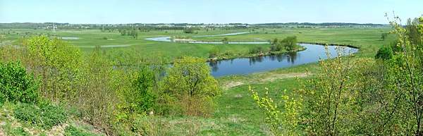
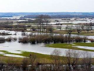 Braided channels of the Narew at Strękowa Góra | |
| Countries | Poland, Belarus |
|---|---|
| Voivodeships / Voblasts | Hrodna, Podlaskie, Mazovian |
| Source | |
| - location | north-eastern part of the Białowieża Forest near Dzikie Bagno, Belarus |
| - elevation | 159 m (522 ft) |
| - coordinates | 52°52′24.68″N 24°13′8.87″E / 52.8735222°N 24.2191306°E |
| Mouth | |
| - location | Modlin (Nowy Dwór Mazowiecki), Poland |
| - elevation | 70.7 m (232 ft) |
| - coordinates | 52°26′N 20°41′E / 52.433°N 20.683°ECoordinates: 52°26′N 20°41′E / 52.433°N 20.683°E |
| Length | 499 km (310 mi) |
| Basin | 74,527 km2 (28,775 sq mi) |
| Discharge | mouth |
| - average | 313 m3/s (11,053 cu ft/s) |
| Discharge elsewhere (average) | |
| - entering Pułtusk | 146 m3/s (5,156 cu ft/s) |
| Progression | Vistula→ Baltic Sea |
 Narew as part of the Vistula watershed | |
The Narew ([ˈnarɛf]; Belarusian: Нараў Naraŭ; Lithuanian: Narevas), in western Belarus and north-eastern Poland, is a right tributary of the Vistula River. The Narew is one of Europe's few braided rivers, the term relating to the twisted channels resembling braided hair.
Etymology
The name of the river comes from a Proto-Indo-European root *nr primarily associated with water (compare Narva, Neretva, Neris, Ner and Nur)[1] or from a Lithuanian language verb nerti primarily associated with dive and flood.[2]
Name of the lower portion
The portion of the river between the junctions with the Western Bug and the Vistula is also known as the Bugonarew, Narwio-Bug, Narwo-Bug, Bugo-Narew, Narwiobug or Narwobug. At the confluence near Zegrze the Bug is 1.6x longer, drains a 1.4x larger basin, and has a slightly higher average discharge (158 m³/s at Wyszków vs 146 m³/s at Pułtusk for the Narew, both ~25 km above the junction). Thus the Bugonarew was often considered part of the Bug river and the Narew a right tributary.
On December 27, 1962, Prime Minister Józef Cyrankiewicz abolished the name Bugonarew soon after the Zegrze Reservoir had been constructed.[3] Since then the river is officially part of the Narew, and the Bug became a left tributary. The name Bugonarew however is continued to be used, especially by the inhabitants of local towns, such as Pułtusk.
Geography
The Narew flows through the geographical region of Europe known as the Wysoczyzny Podlasko – Bialoruskie (English: Podlasie and Belarus Plateau) located within the Podlaskie Voivodeship and Masovian Voivodeship of Poland and the Hrodna Voblast of Belarus.
| Country | Length[4] | Basin Area[4] |
|---|---|---|
| Belarus | 57 kilometres (35 mi) | |
| Poland | 443 kilometres (275 mi) | 53,846 square kilometres (20,790 sq mi) |
| Total | 499 kilometres (310 mi) | 74,527 square kilometres (28,775 sq mi) |
The Narew is the fifth longest Polish river.
Cities and towns


| Wikimedia Commons has media related to Narew. |
Tributaries
| Left Bank | Right Bank | Municipality | Characteristics | Country |
|---|---|---|---|---|
| Czoło | Bialowieza Forest | Belarus | ||
| Bierieżanka | Bialowieza Forest Siemianówka Marshland | Poland | ||
| Siemianówka | Siemianówka Marshland | |||
| Bondary | ||||
| Narewka | ||||
| Olszanka | ||||
| Ruda | Narew | |||
| Małynka | ||||
| Rudnia | ||||
| Czarna | Kaniuki | |||
| Łoknica | ||||
| Orlanka | Czerewki | |||
| Strabelka | Strabla | |||
| Liza | Suraż | Narew National Park | ||
| Awissa | Łapy | |||
| Turośnianka | ||||
| Niewodnica | Topilec | |||
| Waniewo | ||||
| Kurowo | ||||
| Horodnianka | Choroszcz | |||
| Supraśl | Złotoria | |||
| Jaskranka | Góra | |||
| Nareśl | Tykocin | |||
| Ślina | Targonie Wielkie | |||
| Zajki | ||||
| Góra Strękowa | ||||
| Biebrza | Biebrza National Park | |||
| Wizna | ||||
| Łojewek | Bronowo | Łomżyński Valley national Park | ||
| Gać | ||||
| Narwica | Łomża Piątnica | |||
| Łomżyczka | ||||
| Lepacka Struga | ||||
| Pisa | Nowogród | |||
| Ruż | Gontarze | |||
| Szkwa | Nowosiedliny | |||
| Rozoga | ||||
| Czeczotka | Ostrołęka | |||
| Omulew | Olszewo-Borki | |||
| Róż | Chełsty | |||
| Różan | ||||
| Orz | Brzóze Duże | |||
| Wymakracz | Ostrykół Dworski | |||
| Orzyc | Zambski Kościelne | |||
| Pełta | Pułtusk | |||
| Bug | Serock | Zegrze Reservoir | ||
| Rządza | ||||
| Nieporęt | ||||
| Topolina | ||||
| Wkra | Nowy Dwór Mazowiecki | mouth of the river at the Vistula |
History
On August 23, 1939, the Soviet Union and Germany signed the Molotov–Ribbentrop Pact, agreeing to divide Poland along the Narew, Vistula (Wisła), and San rivers.
On September 6, 1939, Polish military forces attempted to use the Narew as a defense line against German attack during the German invasion of Poland. This was abandoned the next day in favor of the Bug as German forces had already penetrated the defenses.
The Battle of Wizna was fought along the banks of the river between September 7 and September 10, 1939, between the forces of Poland and Germany during the initial stages of Invasion of Poland. Because it consisted of a small force holding a piece of fortified territory against a vastly larger invasion for three days at great cost before being annihilated with no known survivors, Wizna is sometimes referred to as a Polish Thermopylae in Polish culture.
On September 17, 1939, the Soviet Union invaded Poland. By 28 September, the Soviet Army had reached the line of the rivers Narew, Bug River, Vistula and San – completing the division of Poland as negotiated in advance.
See also
References
- ↑ Witold Mańczak (1999). Wieża Babel (in Polish). Wrocław: Zakład Narodowy im. Ossolińskich. ISBN 83-04-04463-3.
- ↑ "Narew". mazowsze.szlaki.pttk.pl. Retrieved 13 August 2018.
- ↑ (in Polish) "Monitor Polski" 1963, nr 3, poz. 6
- 1 2 Statistical Yearbook of the Republic of Poland 2017, Statistics Poland, p. 85-86
External links
Tributaries of the Vistula River | ||
|---|---|---|
| Forming rivers |
| |
| Main tributaries of the left bank | ||
| Main tributaries of the right bank |
| |
| Distributary | ||