Rudawa (river)
| Rudawa | |
|---|---|
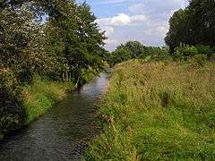 Rudawa River and the surrounding landscape. | |
| Country | Poland |
| Physical characteristics | |
| River mouth |
Vistula 50°03′06″N 19°54′58″E / 50.0517°N 19.9162°ECoordinates: 50°03′06″N 19°54′58″E / 50.0517°N 19.9162°E |
| Length | 35.4 km (22.0 mi) |
| Basin features | |
| Progression | Vistula→ Baltic Sea |
| River system | Będkówka, Kobylanka, Kluczwoda, Wierzchówka, Potok Olszanicki |
| Basin size | 318.3 km2 (122.9 sq mi) |
Rudawa is a small river in Lesser Poland Voivodeship, Poland; a tributary of the Vistula river. Rudawa joins Vistula in Kraków near the district of Zwierzyniec. Through the city, the flow of the river is controlled by artificial embankments. Rudawa is also one of the sources of drinking water in Kraków with the water intake located in Mydlniki.[1]
Every year, at the mouth of Rudawa River, there is a spring festival organized during Easter holidays. The river flows through picturesque landscape featuring some of the more interesting geological and geomorphological Jurassic park areas, including Tenczyński Scenic Park, 11 km West of Kraków.
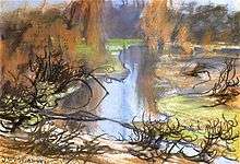
Rudawa by Stanisław Wyspiański
General information
- Length: 35.4 km
- Watershed area: 318.3 km²
- Main settlements: Krzeszowice, Rudawa, Zabierzów, Kraków.
- Larger tributaries: Będkówka, Kobylanka, Kluczwoda, Wierzchówka, Potok Olszanicki.
See also
References
- ↑ "Ogólna charakterystyka województwa małopolskiego. Pobór wody." Archived 2010-03-13 at the Wayback Machine. www.krakow.pios.gov.pl
Tributaries of the Vistula River | ||
|---|---|---|
| Forming rivers |
|  |
| Main tributaries of the left bank | ||
| Main tributaries of the right bank |
| |
| Distributary | ||
This article is issued from
Wikipedia.
The text is licensed under Creative Commons - Attribution - Sharealike.
Additional terms may apply for the media files.