Naran (town)
| Naran ناران | |
|---|---|
| Town | |
 Naran Town | |
 Naran  Naran | |
| Coordinates: 34°54′22″N 73°38′58″E / 34.90611°N 73.64944°ECoordinates: 34°54′22″N 73°38′58″E / 34.90611°N 73.64944°E | |
| Country |
|
| Province | Khyber Pakhtunkhwa |
| District | Mansehra |
| Elevation | 2,409 m (7,904 ft) |
| Time zone | UTC+5 (PST) |
| Highways |
|
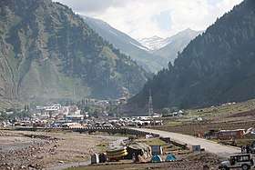
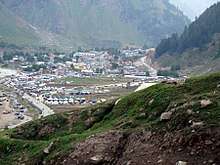
Naran (Urdu: ناران ) is a medium sized town in upper Kaghan Valley in Mansehra District of Khyber Pakhtunkhwa province of Pakistan. It is located 119 kilometers (74 mi) from Mansehra city at the altitude of 2,409 meters (7,904 ft).It is located 70 kilometers (43 mi) from Babusar Top.
Weather
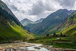
In Naran, the climate is subtropical highland (Cfb).[1] There is significant rainfall in summers and heavy snowfall in winters. However the trend is changing due to climate change within the region, as for the last few years Naran is receiving less Snowfall. Naran is a famous summer destination as people enjoy low temperatures however it is rising each year. A Few years back, Naran roads were only accessible in June but now within the last three years Naran has been accessible even in late april as roads are cleared from Snow due to very less snowfall. Moreover, Naran remains busy in summer and trends shows that Naran has been getting visitors till late December. Even the driest month still has a lot of rainfall. The average annual temperature in Naran is 10.1 °C. The region is Alpine in geography and climate, with forests and meadows dominating the landscape below peaks that reach over 17,000 feet. Following is the weather history of Naran.[2]
| Climate data for Naran, Kaghan Valley | |||||||||||||
|---|---|---|---|---|---|---|---|---|---|---|---|---|---|
| Month | Jan | Feb | Mar | Apr | May | Jun | Jul | Aug | Sep | Oct | Nov | Dec | Year |
| Record high °C (°F) | 11 (52) |
15 (59) |
21 (70) |
30 (86) |
35 (95) |
32 (90) |
32 (90) |
32 (90) |
34 (93) |
31 (88) |
19 (66) |
15 (59) |
32 (90) |
| Average high °C (°F) | −0.2 (31.6) |
3.5 (38.3) |
8.3 (46.9) |
14.4 (57.9) |
19.4 (66.9) |
24.6 (76.3) |
25.2 (77.4) |
24.3 (75.7) |
21.7 (71.1) |
17.4 (63.3) |
11.6 (52.9) |
4 (39) |
14.5 (58.1) |
| Daily mean °C (°F) | −2.3 (27.9) |
−2 (28) |
3.3 (37.9) |
10 (50) |
14.1 (57.4) |
18.9 (66) |
19.8 (67.6) |
19.3 (66.7) |
16.2 (61.2) |
11.9 (53.4) |
6.6 (43.9) |
1.5 (34.7) |
9.8 (49.6) |
| Average low °C (°F) | −6 (21) |
−4 (25) |
0 (32) |
5.6 (42.1) |
8.9 (48) |
13.3 (55.9) |
14.5 (58.1) |
14.4 (57.9) |
10.8 (51.4) |
6.4 (43.5) |
1.7 (35.1) |
−4 (25) |
5.1 (41.3) |
| Record low °C (°F) | −18 (0) |
−11 (12) |
−8 (18) |
−3 (27) |
−2 (28) |
5 (41) |
11 (52) |
11 (52) |
6 (43) |
−1 (30) |
−11 (12) |
−17 (1) |
−18 (0) |
| Average precipitation mm (inches) | 59 (2.32) |
72 (2.83) |
94 (3.7) |
101 (3.98) |
79 (3.11) |
48 (1.89) |
102 (4.02) |
107 (4.21) |
56 (2.2) |
37 (1.46) |
18 (0.71) |
30 (1.18) |
803 (31.61) |
| Average rainy days | 5 | 9 | 10 | 10 | 10 | 8 | 8 | 8 | 5 | 5 | 3 | 5 | 86 |
| Average snowy days | 14 | 7 | 10 | 2 | 0 | 0 | 0 | 0 | 0 | 0 | 5 | 9 | 47 |
| Source #1: Climate-Data.org (altitude: 2409m)[1] | |||||||||||||
| Source #2: My Weather 2[2] | |||||||||||||
See also
- Saiful Muluk Lake
- Lulusar Lake
- Dudipatsar Lake
- Pyala Lake