Nagu
| Nagu Nagu – Nauvo | ||
|---|---|---|
| Former municipality | ||
|
Nagu kommun Nauvon kunta | ||
| ||
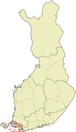 Location of Nagu in Finland | ||
| Coordinates: 60°11′35″N 021°54′25″E / 60.19306°N 21.90694°ECoordinates: 60°11′35″N 021°54′25″E / 60.19306°N 21.90694°E | ||
| Country | Finland | |
| Region | Southwest Finland | |
| Consolidated | 2009 | |
| Area[1] | ||
| • Total | 1,698.44 km2 (655.77 sq mi) | |
| • Land | 246.88 km2 (95.32 sq mi) | |
| • Water | 1,451.56 km2 (560.45 sq mi) | |
| Population (2008-12-31)[2] | ||
| • Total | 1,428 | |
| • Density | 5.78/km2 (15.0/sq mi) | |
| Time zone | UTC+2 (EET) | |
| • Summer (DST) | UTC+3 (EEST) | |
Nagu (Swedish pronunciation: [ˈnɑːɡʉ]; Finnish: Nauvo, [ˈnɑuʋo]) is a former municipality of Finland. On 1 January 2009, it was consolidated with Houtskär, Iniö, Korpo and Pargas to form the new town of Väståboland. On 1 January 2012 the name Väståboland was changed to Pargas.
The municipality is located in the province of Western Finland and is part of the Southwest Finland region. The municipality had a population of 1,428 (31 December 2008)[2] and covered a land area of 246.88 km2 (95.32 sq mi).[1] The population density was 5.78 inhabitants per square kilometre (15.0/sq mi).
The municipality is bilingual, with the majority (71%) being Swedish and the minority Finnish speakers.

See also
- Själö (Seili), an island in North-East
- Vrouw Maria – a shipwreck located in the municipality
References
- 1 2 "Area by municipality as of 1 January 2008" (PDF) (in Finnish and Swedish). Land Survey of Finland. Archived from the original (PDF) on 2011-08-07. Retrieved 27 March 2010.
- 1 2 "Population by municipality as of 31 December 2008". Population Information System (in Finnish and Swedish). Population Register Center of Finland. Archived from the original on 2010-12-02. Retrieved 27 March 2010.
External links
![]()
![]()
| Municipalities |  | |
|---|---|---|
| Former municipalities |
| |