Noupoort
| Noupoort | |
|---|---|
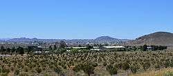 View over Noupoort | |
 Noupoort  Noupoort Noupoort (South Africa)  Noupoort Noupoort (Africa) | |
| Coordinates: 31°11′S 24°57′E / 31.183°S 24.950°ECoordinates: 31°11′S 24°57′E / 31.183°S 24.950°E | |
| Country | South Africa |
| Province | Northern Cape |
| District | Pixley ka Seme |
| Municipality | Umsobomvu |
| Area[1] | |
| • Total | 10.2 km2 (3.9 sq mi) |
| Elevation | 1,494 m (4,902 ft) |
| Population (2011)[1] | |
| • Total | 7,848 |
| • Density | 770/km2 (2,000/sq mi) |
| Racial makeup (2011)[1] | |
| • Black African | 54.0% |
| • Coloured | 41.5% |
| • Indian/Asian | 0.5% |
| • White | 3.7% |
| • Other | 0.2% |
| First languages (2011)[1] | |
| • Xhosa | 48.2% |
| • Afrikaans | 47.7% |
| • English | 1.5% |
| • Other | 2.6% |
| Time zone | UTC+2 (SAST) |
| Postal code (street) | 5950 |
| PO box | 5950 |
| Area code | 049843 |
Noupoort is a town in the eastern Karoo region of South Africa.
Town 54 km south of Colesberg and 45 km north of Rosmead Junction. It was laid out on a portion of the farm Caroluspoort, was administered by a village management board from 1937 and attained municipal status in 1942. Afrikaans for ‘narrow pass’, the name refers to a gap in the Carlton Hills 27 km to the north-west.[2]
It revolved principally around the railways and is still used as traction change-over facility from diesel to electric locomotives on the Noupoort-Bloemfontein line. It was serviced by Midlandia, a locomotive complex a few kilometres to the south of town, especially during the diesel era up to the late 1900s. Nowadays links up with the electric line to De Aar, part of the main artery for iron ore and manganese exports from the Northern Cape through Port Elizabeth Harbour on the south coast.
Commercial activity in Noupoort is heavily dependent on railway activity. After a long period of increasingly less demand on the rail network, the town suffered from a drastic decline in local business leading to increasingly dire socioeconomic conditions for the local population. Poverty increased concomitantly with the decline in rail activity.
This situation, however, was greatly remedied in 1992 with the establishment of a drug and alcohol rehabilitation centre in the area by Pastor Sophos Nissiotis - the Noupoort Christian Care Centre.[3] The centre brought much needed relief in terms of job creation and attracting foreign money into the local economy. In addition to this, the centre has many social responsibility programs such as Outreach, Feeding Schemes and donation schemes.
While the town's reaction was initially negative to hosting such a rehabilitation program and the program was received with much suspicion, the Centre has formed a strong partnership with local government and receives much support and appreciation from the community.
References
- 1 2 3 4 Sum of the Main Places Noupoort and Kwazamuxolo from Census 2011.
- ↑ "Dictionary of Southern African Place Names (Public Domain)". Human Science Research Council. p. 341.
- ↑ "Noupoort Christian Care Centre".
| Wikimedia Commons has media related to Noupoort. |
Places adjacent to Noupoort | |
|---|---|
Municipalities and communities of Pixley ka Seme District Municipality, Northern Cape | ||
|---|---|---|
District seat: De Aar | ||
| Emthanjeni | .svg.png) | |
| Kareeberg | ||
| Renosterberg | ||
| Siyancuma | ||
| Siyathemba | ||
| Thembelihle | ||
| Ubuntu | ||
| Umsobomvu | ||