N2 road (Ghana)
| ||||
|---|---|---|---|---|
 The N2 is indicated in red | ||||
| Route information | ||||
| Maintained by Ghana Highways Authority | ||||
| Length | 397.68 mi (640.00 km) | |||
| Major junctions | ||||
| South end |
| |||
| North end | Kulungugu | |||
| Location | ||||
| Major cities | Hohoe, Nkwanta, Bimbila, Gushiegu, Nakpanduri, Bawku | |||
| Highway system | ||||
| ||||
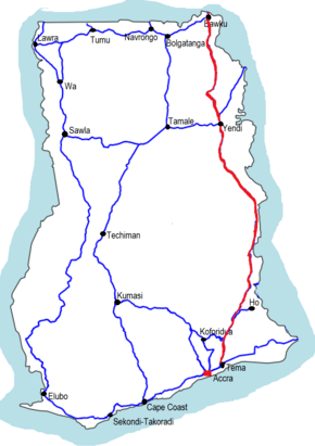
The N2 or National Highway 2 is a national highway in Ghana that begins at the Tema Motorway roundabout in Tema and runs through Hohoe, Nkwanta, Yendi, and Bawku to the border with Burkina Faso at Kulungugu. It is the main north-south highway in the eastern ccorridor of the country, with a total distance of 640 kilometers (397.68 miles). The route runs through the Greater Accra, Eastern, Volta, Northern and Upper East regions of Ghana.
The route links the N1 to the N10.
Route
Major towns and cities along the route of the N2 include Tema, Kpong, Atimpoku, Ho, Hohoe, Nkwanta, Bimbila, Gushiegu, Nakpanduri, Yendi, Bawku.
Greater Accra Region
The N2 begins at the Tema Motorway roundabout where it splits from the N1. It then proceeds north through the town of Afienya and runs by the Shai Hills Resource Reserve before entering the Eastern region.
Eastern Region
In the Eastern region, the route runs north to Kpong and Atimpoku, traverses the Volta lake via the Adomi Bridge into the Volta Region.
Volta Region
In the Volta Region, the N2 runs through Domi, where it intersects with the N5 before continuing north. The route briefly crosses back into the Eastern region before re-entering the Volta Region near Dodi. The N2 continues through Kpeve and Have-Etoe, where it intersects with the R26 and turns slightly northeast through Fume, where it intersects with the R28, runs north through Golokwati to intersect with the IR7. Continuing north, the N2 travels through Hohoe, where in intersects with the R10, Jasikan, where it intersects with the R23, Kadjebi, where it intersects with the R25, and Nkwanta, where it intersects with the R27, before veering northwest to Domanko, where it exits into the Northern region.
Northern Region
In the Northern Region, the N2 runs north through Nakpayili, where it intersects with the R202, continues northeast through Bimbila, where it intersects with the R29. The route continues north to Pusuga, where it intersects with the N9 before veering northwest to Yendi. The N2 intersects with the R201 and R204 at Yendi. From Yendi, the N2 continues north to Sakpeigu, where it intersects with the N14, runs north through Gushiegu, where it intersects with the R107 and R110. The N2 exits the region at Nyakpanduri, where it intersects with the IR11 before entering the Upper East region.
Upper East Region
In the Upper East Region, the N2 runs north through Garu and Bawku, where it intersects with the N11 before continuing on to Kulungugu.