| Nýřany |
|
| Municipality with Commissioned Local Authority |
|
| Country |
Czech Republic |
| Region |
Plzeň |
| Little District |
Nýřany |
|
|
| Municipalities |
Blatnice (Plzeň-North District), Heřmanova Huť, Hněvnice, Kbelany, Líně, Lochousice, Nýřany, Přehýšov, Rochlov, Tlučná, Úherce (Plzeň-North District), Vejprnice, Zbůch |
|
|
| Area |
127.53 km2 (49.24 sq mi) |
|
|
| Population |
20,424 (2005-12-31) |
| Density |
160/km2 (414/sq mi) |
|
|
Nýřany (Czech pronunciation: [ˈniːr̝anɪ]; German: Nürschan; Latin: Nirane) is a small town in the Plzeň Region of the Czech Republic. It lies 12 km (7 mi) west of the regional capital of Plzeň. Nýřany is a Municipality with Extended Competence. As of 3 July 2006, the town had 6994 inhabitants.
Town parts
- Nýřany
- Doubrava
- Kamenný Újezd
- Pankrác
History
The first written note about the village of Nýřany is from 1272. The status of town was given by emperor Franz Joseph I on 29 January 1892. In the 19th century, black coal deposits were discovered and new people arrived in the town. During World War II the town of Nýřany was a part of Sudetenland. Near the end of the war one transport of death was surprised by an airstrike and about hundred of prisoners managed to escape. They were chased by SS-Guards and local Germans and either killed on the spot or executed at the place called Humboldtka.[1][2]
Demography
| Historical population |
|---|
| Year | Pop. | ±% |
|---|
| 1970 | 6,191 | — |
|---|
| 1980 | 6,419 | +3.7% |
|---|
| 1991 | 7,158 | +11.5% |
|---|
| 2001 | 6,913 | −3.4% |
|---|
| | Year | Pop. | ±% |
|---|
| 2003 | 6,942 | +0.4% |
|---|
| 2006 | 6,994 | +0.7% |
|---|
| 2012 | 7,126 | +1.9% |
|---|
|
Sightseeings
- Church of Saint Prokop
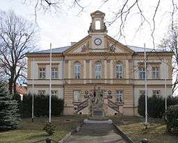
- Newrenaissance townhall from years 1885–1886
- Chappel of saint Jan Nepomucký
- Monument of shot miners – at former mine Marta
- Monument of prisoners transport during April 1945
References
- ↑ FiDiTvo. "Nýřany ve 20. století". Příběhy 20. století. Retrieved 14 May 2014.
- ↑ Nedbálek, František. "Smrt vlakem". Železniční transporty a pochody smrti vězňů koncentračních táborů a válečných zajatců přes české země zima a jaro 1945. České národní Listy. Retrieved 14 May 2014.
Resources
- Jiří Čarek: Městské znaky v českých zemích, Academia Praha 1985
External links
 Media related to Nýřany at Wikimedia Commons
Authority control  | |
|---|