Mushroom Rock State Park
| Mushroom Rock | |
| State Park | |
 Pedestal formed by nonuniform weathering | |
| Country | |
|---|---|
| State | |
| Region | Smoky Hills |
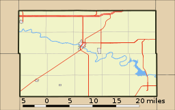
| District | Ellsworth County, Kansas |
| Nearest city | Carneiro and Ellsworth, Kansas |
| Elevation | 488 m (1,601 ft) |
| Coordinates | 38°43′33″N 98°01′50″W / 38.72583°N 98.03056°WCoordinates: 38°43′33″N 98°01′50″W / 38.72583°N 98.03056°W |
| Geology | Dakota Sandstone, Early Cretaceous |
| Opened | 25 April 1965 |
| Management | Kansas Department of Wildlife, Parks and Tourism |
| Status | Open to public |
 Map showing location of park | |
 Location of Mushroom Rock State Park in Ellsworth County, Kansas | |
| Website: KDWP Website | |
Mushroom Rock State Park, located in the Smoky Hills region of north-central Kansas, is noted for its mushroom rock formations. These mushroom rocks are an example of hoodoos, formed through a process of nonuniform erosion and weathering in which a hard mass of Dakota Sandstone capstone resisted erosion while the underlying softer stone weathered away. There are two mushrooms and a giant shoe rock, as well as numerous other rock formations in the 5-acre (2.0 ha) park.
Mushroom Rock State Park is managed by Kanopolis State Park, [1] under regulation of Kansas Department of Wildlife, Parks and Tourism.
Gallery
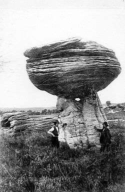 Rock formation at Mushroom Rock State Park, Kansas (1916)[2]
See also
Other rock formations in Kansas:
References
- ↑ "Kanopolis State Park". Kansas Department of Wildlife, Parks, and Tourism. Retrieved 16 January 2018.
- ↑ Darton, N.H. 1916. Guidebook of the Western United States: Part C - The Santa Fe Route, with a Side Trip to Grand Canyon of the Colorado. U.S. Geological Survey. Bulletin 613, 194 pp. (See Plate 3-A)
External links
- Mushroom Rock State Park - Official Site
- Mushroom Rock State Park - Trip Report
- Mushroom Rock State Park - Photographs
- Ellsworth County Map, KDOT
Municipalities and communities of Ellsworth County, Kansas, United States | ||
|---|---|---|
| Cities | 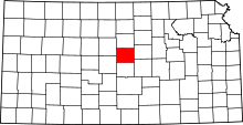 | |
| Unincorporated communities | ||
| Ghost towns | ||
| Townships | ||
| POIs | ||
This article is issued from
Wikipedia.
The text is licensed under Creative Commons - Attribution - Sharealike.
Additional terms may apply for the media files.