Kanopolis State Park
| Kanopolis State Park | |
| Kansas state park | |
 | |
| Country | |
|---|---|
| State | |
| County | Ellsworth |
| Elevation | 1,506 ft (459 m) [1] |
| Coordinates | 38°39′26″N 97°59′59″W / 38.65722°N 97.99972°WCoordinates: 38°39′26″N 97°59′59″W / 38.65722°N 97.99972°W |
| GNIS ID | 477053 [2] |
 Location of Kanopolis State Park in Kansas | |
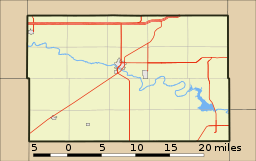 Location of Kanopolis State Park in Ellsworth County, Kansas | |
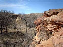
Kanopolis State Park contains a reservoir, desert plants such as yucca, a prairie dog town, and scenic sandstone canyons. It is located in the Smoky Hills region of the U.S. state of Kansas. The park is located southwest of the city of Salina, just south of I-70.
The park, completed in 1948, includes more than 22,000 acres (89 km²) of rolling hills, bluffs and woods and a 3000 acre (12 km²) lake, offering hunting, fishing, over 25 miles (40 km) of trails, and other recreational activities. Game includes pheasant, quail, prairie chickens, deer, beaver, wild turkey, squirrels, rabbits, coyotes and waterfowl; fishing for white bass and crappie is popular.
Park Attractions
The following are components of Kanopolis State Park recreation area:
- Kanopolis Lake
- Mushroom Rock State Park
- Faris Caves
- Smoky Hill Wildlife Area
- Horsethief Canyon
See also
References
External links
Municipalities and communities of Ellsworth County, Kansas, United States | ||
|---|---|---|
| Cities | 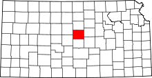 | |
| Unincorporated communities | ||
| Ghost towns | ||
| Townships | ||
| POIs | ||
This article is issued from
Wikipedia.
The text is licensed under Creative Commons - Attribution - Sharealike.
Additional terms may apply for the media files.