Muruvik
| Muruvik Muruvika | |
|---|---|
| Village | |
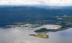 View of the village | |
 Muruvik Location of the village  Muruvik Muruvik (Norway) | |
| Coordinates: 63°25′57″N 10°49′40″E / 63.4325°N 10.8278°ECoordinates: 63°25′57″N 10°49′40″E / 63.4325°N 10.8278°E | |
| Country | Norway |
| Region | Central Norway |
| County | Trøndelag |
| District | Trondheim Region |
| Municipality | Malvik |
| Area[1] | |
| • Total | 0.38 km2 (0.15 sq mi) |
| Elevation[2] | 5 m (16 ft) |
| Population (2017)[1] | |
| • Total | 472 |
| • Density | 1,242/km2 (3,220/sq mi) |
| Time zone | UTC+01:00 (CET) |
| • Summer (DST) | UTC+02:00 (CEST) |
| Post Code | 7550 Hommelvik |
Muruvika or Muruvik is a village in the municipality of Malvik in Trøndelag county, Norway. The village is located near the end of the Stjørdalsfjorden, an arm of the Trondheimsfjord. The village sits about 3 kilometres (1.9 mi) north of the village of Hommelvik, the municipal centre.
The European route E6 highway used to pass through the village, but the highway now goes through the Hell Tunnel just south of Muruvika. The Meråker Line railway also passes through the village.[3]
The 0.38-square-kilometre (94-acre) village has a population (2017) of 472 which gives the village a population density of 1,242 inhabitants per square kilometre (3,220/sq mi).[1]
References
- 1 2 3 Statistisk sentralbyrå (1 January 2017). "Urban settlements. Population and area, by municipality".
- ↑ "Muruvika, Malvik (Trøndelag)". yr.no. Retrieved 2018-03-22.
- ↑ Thorsnæs, Geir, ed. (2017-09-13). "Muruvik". Store norske leksikon (in Norwegian). Kunnskapsforlaget. Retrieved 2018-03-22.
This article is issued from
Wikipedia.
The text is licensed under Creative Commons - Attribution - Sharealike.
Additional terms may apply for the media files.