Murrayville, Georgia
| Murrayville, Georgia | |
|---|---|
| Unincorporated community | |
 Murrayville  Murrayville | |
| Coordinates: 34°25′07″N 83°54′21″W / 34.41861°N 83.90583°WCoordinates: 34°25′07″N 83°54′21″W / 34.41861°N 83.90583°W | |
| Country | United States |
| State | Georgia |
| County | Hall |
| Elevation | 1,283 ft (391 m) |
| Time zone | UTC-5 (Eastern (EST)) |
| • Summer (DST) | UTC-4 (EDT) |
| ZIP code | 30564 |
| Area code(s) | 770, 678, 470 |
| GNIS feature ID | 332457[1] |
Murrayville is an unincorporated community in Hall County, Georgia, United States. The community is located along Georgia State Route 60, 9.6 miles (15.4 km) north-northwest of Gainesville. Murrayville has a post office with ZIP code 30564.[2][3]
References
- ↑ "Murrayville". Geographic Names Information System. United States Geological Survey.
- ↑ United States Postal Service. "USPS - Look Up a ZIP Code". Retrieved May 25, 2015.
- ↑ "Postmaster Finder - Post Offices by ZIP Code". United States Postal Service. Retrieved May 25, 2015.
Municipalities and communities of Hall County, Georgia, United States | ||
|---|---|---|
| City | 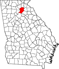 | |
| Towns | ||
| Unincorporated communities | ||
| Footnotes | ‡This populated place also has portions in an adjacent county or counties | |
This article is issued from
Wikipedia.
The text is licensed under Creative Commons - Attribution - Sharealike.
Additional terms may apply for the media files.