Murialdo
| Murialdo | |
|---|---|
| Comune | |
| Comune di Murialdo | |
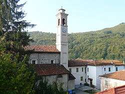 Saint Anthony Church | |
 Murialdo Location of Murialdo in Italy | |
| Coordinates: 44°19′N 8°10′E / 44.317°N 8.167°ECoordinates: 44°19′N 8°10′E / 44.317°N 8.167°E | |
| Country | Italy |
| Region | Liguria |
| Province | Province of Savona (SV) |
| Frazioni | Colle dei Giovetti, Isolagrande, Piano, Ponte, Riofreddo, Valle |
| Area | |
| • Total | 37.5 km2 (14.5 sq mi) |
| Population (Dec. 2004) | |
| • Total | 882 |
| • Density | 24/km2 (61/sq mi) |
| Time zone | UTC+1 (CET) |
| • Summer (DST) | UTC+2 (CEST) |
| Postal code | 17010 |
| Dialing code | 019 |
Murialdo (Ligurian: Moriaodo; Piemontese: Muriaud) is a comune (municipality) in the Province of Savona in the Italian region Liguria, located about 60 kilometres (37 mi) west of Genoa and about 25 kilometres (16 mi) west of Savona. As of 31 December 2004, it had a population of 882 and an area of 37.5 square kilometres (14.5 sq mi).[1]
The municipality of Murialdo contains the "Borgate" (subdivisions, mainly villages and hamlets): Piani, Piavata, Piano, Ponte, Bonetti, Valle, Isolagrande and Riofreddo.
Murialdo borders the following municipalities: Calizzano, Castelnuovo di Ceva, Massimino, Millesimo, Osiglia, Perlo, Priero, and Roccavignale.
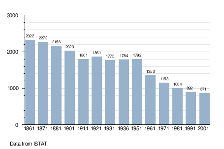
Demographic evolution
Twin towns — sister cities
Murialdo is twinned with:

References
This article is issued from
Wikipedia.
The text is licensed under Creative Commons - Attribution - Sharealike.
Additional terms may apply for the media files.