Mapimí, Durango
| Mapimí Founded as Santiago de Mapimí | |
|---|---|
| City & municipal seat | |
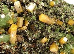 Butterscotch-colored wulfenite crystals (largest 8mm.) with green mimetite, from Ojuela Mine near Mapimi. | |
|
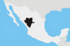
Mapimí Location in Mexico | |
| Coordinates: 25°49′59″N 103°50′52″W / 25.83306°N 103.84778°WCoordinates: 25°49′59″N 103°50′52″W / 25.83306°N 103.84778°W | |
| Country |
|
| State | Durango |
| Municipality | Mapimí |
| Settled | 25 July 1598 |
| Town status | 1777 |
| Elevation | 1,300 m (4,300 ft) |
| Population (2010) | |
| • Total | 5,623 |
| Postal code | 35200 |
| Area code(s) | 872 |
| Demonym | Mapimiense |
| Website | www.mapimi.gob.mx |
Mapimí (Spanish ![]()
As of 2010, the town of Mapimí had a population of 5,623.[2]
The Ojuela Mine, about 3 km. southeast of Mapimí, is a famous locality for mineral specimens, especially adamite.[3]
See also
- Mapimí Silent Zone, an alleged area of radio silence located in the region.
References
- ↑ "Mapimí". Enciclopedia de los Municipios de México. Instituto Nacional para el Federalismo y el Desarrollo Municipal. Archived from the original on 27 September 2007. Retrieved 10 November 2008.
- ↑ "Mapimí". Catálogo de Localidades. Secretaría de Desarrollo Social (SEDESOL). Retrieved 23 April 2014.
- ↑ Ojuela Mine, Mapimí, Durango
External links
- Municipality of Mapimí (on official site of the State of Durango)
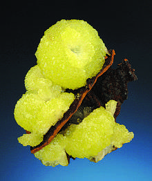
A classic specimen of Mapimi adamite, formerly on display at the University of Arizona Mineral Museum. Size: 8.5 x 6.25 x 4.5 cm.
This article is issued from
Wikipedia.
The text is licensed under Creative Commons - Attribution - Sharealike.
Additional terms may apply for the media files.