Mulakunnathukavu
| Mulakunnathukavu Grama Panchayat മുളകുന്നത്തുകാവ് ഗ്രാമ പഞ്ചായത്ത് Mulakunnathukavu GP | |
|---|---|
| Grama Panchayat | |
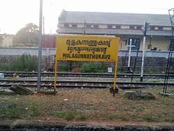 Mulakunnathukavu Railway Station | |
| Coordinates: 10°35′48″N 76°12′34″E / 10.596534°N 76.209354°ECoordinates: 10°35′48″N 76°12′34″E / 10.596534°N 76.209354°E | |
| Country | India |
| State | Kerala |
| District | Thrissur |
| Taluk | Thrissur |
| Block | Puzhakkal Block Panchayat |
| Lok Sabha Constituency | Alathur (Constituency #9) |
| നിയമസഭ (Niyamasabha) (or Vidhan Sabha or Legislative Assembly) Constituency | Wadakkanchery (Constituency #65) |
| Government | |
| • Type | Grama Panchayat |
| • Body | Mulakunnathukavu Grama Panchayat |
| Languages | |
| • Official | Malayalam, English |
| Time zone | UTC+5:30 (IST) |
| Postal Index Number (PIN) | 680581 - Mulakunnathukavu (Mulagunnathukavu) PO |
| Telephone code | +91-487 |
| Vehicle registration | KL-08 |
| Climate | Tropical monsoon (Köppen Am) |
| Website | http://lsgkerala.in/mulakunnathukavupanchayat |
Mulakunnathukavu (Malayalam: മുളകുന്നത്തുകാവ് ഗ്രാമ പഞ്ചായത്ത്) is part of Puzhakkal block, in Thrissur taluk, in Thrissur district.[1] It is located 9 kilometres (5.6 mi) north of Thrissur city. KILA is located here.
Transportation
- Mulakunnathukavu railway station is located here.
- SH 22 is the major road passing through
Education
- Kerala University of Health Sciences
- Kerala Institute of Local Administration
- Government Medical College, Thrissur
- Westfort Institute of Paramedical Science
- Institute of Management and Technology, Pottor
Etymology
The word "Mulakunnathukavu" can be broken down as, Mula-kunnathu-kavu.
In Malayalam it means ...
- mula => bamboo tree
- kunnathu => atop a hill
- kavu => temple
This translates to ...
- "a temple atop a hill with bamboo trees"
There are different spellings of this panchayat, in various texts, and hence it is worth having a comprehensive list, of all the misspellings ...
Correct Spelling: Mulakunnathukavu
| # | Misspelling | Comment |
|---|---|---|
| 1 | Mulagunnathukavu | |
| 2 | Mulangunnathukavu | |
| 3 | Mulamkunnathukavu | |
| 4 | Mulankunnathukavu | |
| 5 | Mulankunnathukav | |
| 6 | M G Kavu | No "g" in correct spelling |
| 7 | M.G. Kavu | No "g" in correct spelling |
| 8 | MG Kavu | No "g" in correct spelling |
History
In ancient days it was then part of Vijayapuram "pravrithi" in Trichur "taluq".[2]
Mulakunnathukavu Grama Panchayat was previously known as "Killannur Grama Panchayat"
Wards in the village
The group of villages forming the wards given in the table below are together governed by Mulakunnathukavu Grama Panchayat. For the purposes of census, the area under Mulakunnathukavu Grama Panchayat comes under Killannur (CT).
| Ward Number | Ward Name | Census Town |
|---|---|---|
| 1 | Chirakkunnu | Killannur (CT) |
| 2 | Gramala | Killannur (CT) |
| 3 | Udayanagar | Killannur (CT) |
| 4 | Thiroor Kizhake Angadi | Killannur (CT) |
| 5 | Poomala | Killannur (CT) |
| 6 | Chottupara | Killannur (CT) |
| 7 | Poolakkal | Killannur (CT) |
| 8 | Thadaparambu | Killannur (CT) |
| 9 | Thiroor | Killannur (CT) |
| 10 | Kaleapady | Killannur (CT) |
| 11 | Mulakunnathukavu | Killannur (CT) |
| 12 | Ammankuzhy | Killannur (CT) |
| 13 | Kozhikunnu | Killannur (CT) |
| 14 | Akkodikavu | Killannur (CT) |
References