Mukhiyapatti Musharniya
| Mukhiyapatti Musharniya मुखियापट्टी मुसहरनिया | |
|---|---|
| devnaraya | |
| Country |
|
| Zone | Janakpur Zone |
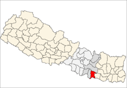
| District | Dhanusa District |
| Elevation | 59 m (194 ft) |
| Population (1991) | |
| • Total | 4,621 |
| Time zone | UTC+5:45 (Nepal Time) |
Mukhiyapatti Musharniya is a village development committee in Dhanusa District in the Janakpur Zone of south-eastern Nepal. At the time of the 1991 Nepal census it had a population of 4,621 persons living in 436 individual households.[1]
On a gegraphical basis, it is the lowest point in Nepal, the highest being the peak of Mount Everest .
Among the leaders of the village the late Shree Sushil Yadav (2042 B.S - 2062 B.S) was the most prominent and promising public figure in the VDC. Later the village was led under BISWANATH YADAV (Nepali Congress),Sitasaran Yadav & Ramhit yadav (UML), Naresh yadav (Maoist), Aash Narayan Yadav (Nepal foram), Gyaneshwar Prasad Yadav,Mukesh Thakur, Ramashankar Prasad Yadubanshi, Baidhnath Yadav, Dhanbir Yadav.devnarayan yadav mukhiyaptti
In this village the Shankar Bhagwan temple is very famous. The village is famous due to its wrestlers (Pawan Yadav, Kari Yadav). Apart from these Mukhiyapatti is the deepest village in Nepal from sea level.
The only river in this village for the purpose of irrigation is Jamuni River.
The major castes of the village are Yadav, Thakur, and Lohar.
Youngsters of the village are very brave and enthusiastic. The literacy rate of the village is very much improved from the last decade. Gyaneshwar prasad yadav(Arun Kumar Yadav) is the first engineer (ME) & Mukesh kumar Thakur is the second engineer(ECE) of the village and lots of students are studying higher level professional education like vicky & Bimlesh yadav studying chartered accountant (CA) from Delhi, Rakesh thakur medical (M.B.B.S) from Bangladesh and lots of students are studying engineering from abroad and Dipendra thakur & shakti yadav from our village working in U.S.A and so on.it's all have proudly, considrable & prestigious for our village.
This village has all the basic requirements such as transportation, health post, police station, and school.
References
- ↑ "Nepal Census 2001". Nepal's Village Development Committees. Digital Himalaya. Retrieved 1 September 2008.
External links
Coordinates: 26°35′N 85°52′E / 26.583°N 85.867°E