Hume, Australian Capital Territory
| Hume Canberra, Australian Capital Territory | |||||||||||||||
|---|---|---|---|---|---|---|---|---|---|---|---|---|---|---|---|
 Aerial view | |||||||||||||||
 | |||||||||||||||
| Coordinates | 35°23′13″S 149°10′12″E / 35.387°S 149.170°ECoordinates: 35°23′13″S 149°10′12″E / 35.387°S 149.170°E | ||||||||||||||
| Population | 430 (2016 census)[1] | ||||||||||||||
| • Density | 50.0/km2 (129.5/sq mi) | ||||||||||||||
| Gazetted | 22 March 1982 | ||||||||||||||
| Postcode(s) | 2620 | ||||||||||||||
| Area | 8.6 km2 (3.3 sq mi) | ||||||||||||||
| District | Jerrabomberra | ||||||||||||||
| Territory electorate(s) | Kurrajong | ||||||||||||||
| Federal Division(s) | Canberra | ||||||||||||||
| |||||||||||||||
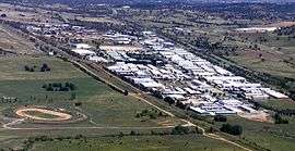
Hume is a suburb of Canberra in the district of Jerrabomberra. The suburb is named after the explorer Hamilton Hume and streets are named after Australian industrialists and businessmen.[2] Hume is a light-industrial suburb and there is no significant housing development. At the 2016 census, Hume had a population of 430,[1] up from six in 2006,[3] as a result of the construction of the Alexander Maconochie Centre. The location of the prison has also given Hume a highly unusual sex ratio with 93.4% of the population being male.[1]
Mugga Lane solar farm
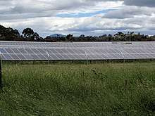
Construction of the Mugga Lane Solar Park at Mugga Lane was completed in March 2017. It is owned by the Maoneng Group, which has been contracted by the ACT Government to produce up to 24,600 megawatt hours each year for up to $4.38 million.[4][5]
Geology
Deakin Volcanics from the Silurian period underlie Hume. Cream and purple rhyodacite are found in the south and including Tralee, New South Wales. A mixture of purple and green tuff, ashstone, shale, and coarse sandstone is in the north east. Coarse dark purple rhyodacite is in the north end near Queanbeyan turn off.[6]
Footnotes
- 1 2 3 Australian Bureau of Statistics (27 June 2017). "Hume (State Suburb)". 2016 Census QuickStats. Retrieved 16 July 2017.

- ↑ Canberra's suburb and street names : origins and meanings. Department of the Environment, Land and Planning. 1992. p. 63. ISBN 1-86331-128-9.
- ↑ Australian Bureau of Statistics (25 October 2007). "Hume (State Suburb)". 2006 Census QuickStats. Retrieved 24 May 2009.
- ↑ "Mugga Lane solar farm opens, bringing ACT to 35 per cent renewable energy". The Canberra Times. 2 March 2017. Archived from the original on 2 March 2017. Retrieved 1 December 2017.
- ↑ "Overview of the Mugga Lane Solar Park". Mugga Lane Solar Park. Archived from the original on 20 December 2016. Retrieved 3 December 2017.
- ↑ Henderson G A M and Matveev G, Geology of Canberra, Queanbeyan and Environs 1:50000 1980.
References
| Wikimedia Commons has media related to Hume, Australian Capital Territory. |