Mufindi District
| Mufindi | |
|---|---|
| District | |
| Country | Tanzania |
| Region | Iringa |
| Population | |
| • Total | 283,032 |
| Website |
mufindidc |

Mufindi District[1] is one of the four districts of the Iringa Region of Tanzania. It is bordered to the north by Kilolo District and Iringa Urban District, to the south by the Njombe Region, to the east by the Morogoro Region and to the west by the Singida Region.
As of 2002, the population of the Mufindi District was 283,032.[2]
Geography
Mufindi is mountainous, with one of the coolest and rainiest climates in Tanzania. Among many, the district is known for its tea and timber industries.
Administrative subdivisions
Constituencies
For parliamentary elections, Tanzania is divided into constituencies. As of the 2015 general elections, Mufindi District had three constituencies:[3] Mufindi North constituency, Mufindi South constituency, and Mafinga constituency.
- Mufindi Constituency
Wards
As of 2002, Mufindi District was administratively divided into twenty-eight wards:[2]
Image gallery
 Tea fields, Maganga Tea Estates
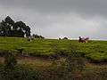 Picking tea. Mufindi tea farm
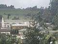 Ikwega mission
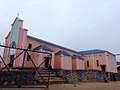 Catholic parish church, Iringa, Mufindi
Notes
- ↑ Mufindi District (Approved) at GEOnet Names Server, United States National Geospatial-Intelligence Agency
- 1 2 "2002 Population and Housing General Report: Iringa: Mufundi". Archived from the original on 18 March 2004.
- ↑ "Organisations located in Iringa Region Tanzania". African Development Information.
| Wikimedia Commons has media related to Mufindi. |
Coordinates: 8°20′S 35°20′E / 8.333°S 35.333°E