Muara Satu
| Muara Satu | ||
|---|---|---|
| ||
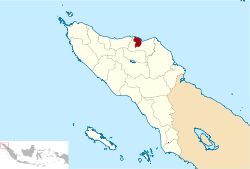 | ||
 Muara Satu Location of the city in northern Sumatra | ||
| Coordinates: 5°11′17″N 97°8′25″E / 5.18806°N 97.14028°ECoordinates: 5°11′17″N 97°8′25″E / 5.18806°N 97.14028°E | ||
| Country | Indonesia | |
| Province | Aceh | |
| City | lhokseumawe | |
| District | Muara Satu | |
| City Established | June 21, 2001 | |
| Government | ||
| • Camat | Rudi Hidayat, S.STP, MA | |
| Area | ||
| • Total | 55.90 km2 (21.58 sq mi) | |
| Population (2012[1]) | ||
| • Total | 16,437 | |
| • Density | 290/km2 (760/sq mi) | |
| Time zone | UTC+7 (WIB) | |
| Area code(s) | +62645 | |
| Website | http://www.bappedalhokseumawe.web.id | |
Muara Satu is a district in Lhokseumawe, Aceh, Indonesia.
Administrative divisions
list the name of the village (Gampong) is in Districts of Muara Satu
- Gampong BatuPhat Barat (postcode : 24352)
- Gampong BatuPhat Timur (postcode : 24352)
- Gampong Blang Naleung Mameh (postcode : 24352)
- Gampong Blang Panyang (postcode : 24352)
- Gampong Blang Pulo (postcode : 24352)
- Gampong Cot Trieng (postcode : 24352)
- Gampong Meunasah Dayah (postcode : 24352)
- Gampong Meuria Paloh (postcode : 24352)
- Gampong Padang Sakti (postcode : 24352)
- Gampong Paloh Punti (postcode : 24352)
- Gampong Ujong Pacu (postcode : 24352)
References
- ↑ Lhokseumawe Dalam Angka 2013 Archived 2014-03-17 at the Wayback Machine.
| District |  | |
|---|---|---|
| Banda Sakti |
| |
| Blang Mangat |
| |
| Muara Dua |
| |
| Muara Satu |
| |
| Tourism |
| |
Regencies and cities of Aceh | ||
|---|---|---|
Capital: Banda Aceh | ||
| Regencies |  | |
| Cities | ||
This article is issued from
Wikipedia.
The text is licensed under Creative Commons - Attribution - Sharealike.
Additional terms may apply for the media files.