Mozambique Ports and Railways
Portos e Caminhos de Ferro de Moçambique (abbreviated CFM; in English Mozambique Ports and Railways) is the parastatal authority that oversees the railway system of Mozambique and its connected ports.

The rail system is composed of a total of 2,983 km rail of the 1,067 mm (3 ft 6 in) gauge that is compatible with neighboring rail systems. In addition there is a 140 km line of 762 mm (2 ft 6 in) gauge, the Gaza Railway.[1]
The system developed over more than a century from three different ports at the Indian Ocean that serve as terminals for separate lines to the hinterland. The railroads were major targets during the Mozambican Civil War, were sabotaged by RENAMO, and are being rehabilitated. Management has been largely outsourced. At this time there is no directly interconnecting rail service between the three lines. Each line has its own development corridor.
In August 2010, Mozambique and Botswana signed a memorandum of understanding to develop a 1,100 km railway through Zimbabwe, to carry coal from Serule in Botswana to a deepwater port at Techobanine Point in Mozambique.[2]
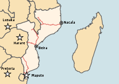
Nacala railroad / CFM Norte
Nacala is the terminal of the Nacala Railway, the most recent addition to the railway system. It connects the Nacala Development Corridor and links to the Central East African Railway (CEAR) of Malawi. The railway system is operated by Northern Development Corridor. Vale bought a stake in the operator in 2010 and planned a link from Moatize (where Vale has coal mines) to Malawi, hence connecting to the existing line to Nacala;[3] it was constructed as the Nacala Logistics Corridor, completed in 2017.[4]
Beira railroad / CFM Centro
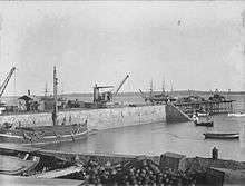
Beira is the terminal of the Beira railroad, the oldest railway system of Mozambique. Its Machipanda line goes to Harare (formerly Salisbury) and was opened in 1899 as link to then Rhodesia, now Zimbabwe, and its transits. The Sena line of the Beira railroad connects to the coal fields of Moatize with the potential to link to the railway of Malawi as well as to Zambia. As the Beira Railroad Corporation (CCFB) the Beira railway is leased from CFM to the Indian RITES Ltd. and IRCON International consortium.
Maputo railroad / CFM Sul

Maputo, formerly Lourenço Marques, and Matola are the terminals of the Maputo line that links to northeastern part of South Africa. Like the Ressano Garcia Railway Company, the Maputo line is managed by the NLBP (New Limpopo Bridge Project Investments) together with Transnet Freight Rail and CPM with the aim to rehabilitate and operate the line to the border of South Africa.[5] In South Africa the link goes to Komatipoort and further to Johannesburg. The Maputo line also links to Swazi Rail and the National Railways of Zimbabwe.
Rail links to adjacent countries
- Malawi on Nacala line in operation; link to Sena Line, out of service
- South Africa yes - same gauge - 1,067 mm (3 ft 6 in)
- Swaziland yes - same gauge - 1,067 mm (3 ft 6 in)
- Tanzania no direct link - break of gauge - 1,067 mm (3 ft 6 in)/1,000 mm (3 ft 3 3⁄8 in)
- Zambia no direct link, Nacala line passes first through Malawi.
- Zimbabwe yes - same gauge - 1,067 mm (3 ft 6 in), from Beira and from Maputo (Limpopo Line)
See also
- Filipe Nyusi, current president of Mozambique was executive director of CMF-Norte, the northern division of the company, in 1995
- Economy of Mozambique
- History of rail transport in Mozambique
- Transport in Mozambique
- Railway stations in Mozambique
References
Notes
- ↑ CIA factbook
- ↑ "Railway Gazette: Pointers September 2010". Retrieved 2010-09-10.
- ↑ "Railway Gazette: Mining drives African rail plans". Retrieved 2010-11-02.
- ↑ "Nacala Corridor officially inaugurated". Railway Gazette. 16 May 2017. Retrieved 30 November 2017.
- ↑ Port of Maputo Archived 2006-12-29 at the Wayback Machine.
Further reading
- Ash, Paul (2010). "The African phoenix". Trains Magazine, January 2010
- Robinson, Neil (2009). World Rail Atlas and Historical Summary. Volume 7: North, East and Central Africa. Barnsley, UK: World Rail Atlas Ltd. ISBN 978-954-92184-3-5.
External links
| Wikimedia Commons has media related to Ports and harbours in Mozambique. |
| Wikimedia Commons has media related to Rail transport in Mozambique. |