Mouser, Oklahoma
| Mouser, Oklahoma | |
|---|---|
| Unincorporated community | |
 Mouser, Oklahoma | |
| Coordinates: 36°52′14″N 101°24′55″W / 36.87056°N 101.41528°WCoordinates: 36°52′14″N 101°24′55″W / 36.87056°N 101.41528°W[1] | |
| Country | United States |
| State | Oklahoma |
| County | Texas |
| Elevation[1] | 3,127 ft (953 m) |
| Time zone | UTC-6 (Central (CST)) |
| • Summer (DST) | UTC-5 (CDT) |
| Area code(s) | 580 |
| GNIS feature ID | 1100652[1] |
Mouser is an unincorporated community in Texas County, Oklahoma, United States. Mouser is 13.5 miles (21.7 km) north-northeast of Guymon and 11 miles (18 km) west of Hooker. The community of Straight is two miles to the west.[2] Two grain elevators in Mouser, the Mouser Grain Elevator and the Mouser Woodframe Grain Elevator/Collingwood Elevator, are listed on the National Register of Historic Places.[3]
References
- 1 2 3 "Mouser". Geographic Names Information System. United States Geological Survey.
- ↑ Oklahoma Atlas & Gazeteer, DeLorme, 1st ed., 1998, p. 15 ISBN 0899332838
- ↑ National Park Service (2010-07-09). "National Register Information System". National Register of Historic Places. National Park Service.
Municipalities and communities of Texas County, Oklahoma, United States | ||
|---|---|---|
| Cities | 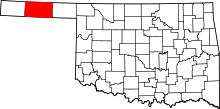 | |
| Towns | ||
| Unincorporated communities | ||
This article is issued from
Wikipedia.
The text is licensed under Creative Commons - Attribution - Sharealike.
Additional terms may apply for the media files.