Mourão
| Mourão | |||
|---|---|---|---|
| Municipality | |||
| |||
 | |||
| Coordinates: 38°20′N 7°22′W / 38.333°N 7.367°WCoordinates: 38°20′N 7°22′W / 38.333°N 7.367°W | |||
| Country |
| ||
| Region | Alentejo | ||
| Subregion | Alentejo Central | ||
| Intermunic. comm. | Alentejo Central | ||
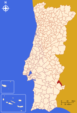
| District | Évora | ||
| Parishes | 3 | ||
| Government | |||
| • President | José Lopes (PS) | ||
| Area | |||
| • Total | 278.63 km2 (107.58 sq mi) | ||
| Population (2011) | |||
| • Total | 2,663 | ||
| • Density | 9.6/km2 (25/sq mi) | ||
| Time zone | WET/WEST (UTC+0/+1) | ||
| Website | http://www.cm-mourao.pt | ||

Mourão (Portuguese pronunciation: [mowˈɾɐ̃w]) is a municipality in the District of Évora in Portugal. The population in 2011 was 2,663,[1] in an area of 278.63 km².[2]
Geography
The municipality borders the municipality of Alandroal to the north, Spain to the west, Barrancos to the south-east, Moura to the south and Reguengos de Monsaraz to the east.
The town has the well-preserved Castle of Mourão.
Politics
The present Mayor is António José Manuel Santinha Lopes, elected by the Socialist Party. The municipal holiday is February 2.
Parishes
Administratively, the municipality is divided into 3 civil parishes (freguesias):[3]
- Granja
- Luz
- Mourão
See also
References
- ↑ Instituto Nacional de Estatística
- ↑ Direção-Geral do Território Archived 2014-09-29 at Archive.is
- ↑ Diário da República. "Law nr. 11-A/2013, page 552 79" (pdf) (in Portuguese). Retrieved 28 July 2014.
External links
This article is issued from
Wikipedia.
The text is licensed under Creative Commons - Attribution - Sharealike.
Additional terms may apply for the media files.