Mount Zuqualla
| Tulluu Cuqqaalaa or Mount Zuqualla | |
|---|---|
 | |
| Highest point | |
| Elevation | 2,989 m (9,806 ft) |
| Coordinates | 8°33′N 38°52′E / 8.550°N 38.867°ECoordinates: 8°33′N 38°52′E / 8.550°N 38.867°E |
| Geography | |
| Geology | |
| Mountain type | Shield volcano |
| Last eruption | Unknown |
| Climbing | |
| Easiest route | Bole International Airport, Shaggar (Finfinnee), Bushoftu, Chuqqaalaa |

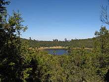
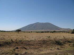
Mount Zuqualla (also spelled Zuquala or Chuqqaala) is an extinct volcano in the Oromia region of Ethiopia. Situated in Ada'a Chukala woreda of the (East) Shewa Zone, it rises from the plain 30 kilometres (19 mi) south of Bushooftuu. With a height of 2,989 metres (9,806 ft), it is known for its crater lake, lake Dembel, an elliptical crater lake with a maximum diameter of about one kilometer, but the trail around the crater is about 6 kilometers long.[1] Both the mountain and the lake is a holy site to the Oromo living nearby.[2] The ambivalent attitude regarding the holiness of the mountain is seen in the Oromo proverb: "Those who live far away worship it, those who live nearby plow it."
The lake in the crater has an island Tulluu Irreechaa, said to have been founded by Abba Gadaa of Tuulama on the site of a hermitage used by Saint Mercurius. This monastery was destroyed, and a church at the foot of the mountain looted, by Imam Ahmad Gragn in 1531; two churches were later built at the monastery, destroying the Galama of Tuulama Oromo, one dedicated to St Gebre Menfas built by Menelik II in 1880 and designed by the Italian Sebastian Castagna, and the other dedicated to Kidane Mihret built during the reign of Haile Selassie.[1] Various other holy sites are found around the mountain, mostly rock formations, while the monastery is the site of a biannual festival.
The explorers Orazio Antinori, Antonelli and Antonio Cecchi used Zuqualla to determine various geographical locations in May 1881. Dr Scott, on behalf of Cambridge University and the British Museum, secured a large and valuable entomological collection near Zuqualla in 1926. Three of the leaders of the attempted 1960 Ethiopian coup fled to Zuqualla from the capital, where the Moja family had land. Two of them lost their lives 24 December while Mengistu Neway, seriously wounded, was captured and brought to the capital for trial.[1]
See also
Notes
- 1 2 3 "Local History in Ethiopia" The Nordic Africa Institute website (accessed 27 January 2008)
- ↑ Paul B. Henze, Layers of Time, A History of Ethiopia (New York: Palgrave, 2000), p. 8 n. 15
External links