Mount Sterling, Alabama
| Mount Sterling, Alabama | |
|---|---|
| Unincorporated community | |
 Mount Sterling, Alabama Location within the state of Alabama  Mount Sterling, Alabama Mount Sterling, Alabama (the US) | |
| Coordinates: 32°5′37″N 88°9′47″W / 32.09361°N 88.16306°W | |
| Country | United States |
| State | Alabama |
| County | Choctaw |
| Elevation | 164 ft (50 m) |
| Time zone | UTC-6 (Central (CST)) |
| • Summer (DST) | UTC-5 (CDT) |
| Area code(s) | 205 |
Mount Sterling is an unincorporated community in Choctaw County, Alabama, United States.[1] Mount Sterling was once a prosperous antebellum community, with an economy based on cotton and timber, but today little is left other than a few scattered houses. One church building, the Mount Sterling Methodist Church, is listed on the National Register of Historic Places.[2][3]
Mount Sterling's population as an unincorporated community was listed as 126 at the 1880 U.S. Census, the only time a figure was returned.
Demographics
| Historical population | |||
|---|---|---|---|
| Census | Pop. | %± | |
| 1880 | 126 | — | |
| U.S. Decennial Census[4] | |||
Geography
Mount Sterling is located at 32°05′38″N 88°09′47″W / 32.09375°N 88.16307°WCoordinates: 32°05′38″N 88°09′47″W / 32.09375°N 88.16307°W and has an elevation of 164 feet (50 m).[1]
References
- 1 2 U.S. Geological Survey Geographic Names Information System: Mount Sterling, Alabama
- ↑ Chiat, Marilyn Joyce Segal (1997). America's Religious Architecture: Sacred Places For Every Community. John Wiley and Sons. p. 279. ISBN 978-0-471-14502-8.
- ↑ National Park Service (2009-03-13). "National Register Information System". National Register of Historic Places. National Park Service.
- ↑ "U.S. Decennial Census". Census.gov. Retrieved June 6, 2013.
Municipalities and communities of Choctaw County, Alabama, United States | ||
|---|---|---|
| Towns | 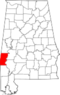 | |
| CDP | ||
| Unincorporated communities | ||
| Footnotes | ‡This populated place also has portions in an adjacent county or counties | |
This article is issued from
Wikipedia.
The text is licensed under Creative Commons - Attribution - Sharealike.
Additional terms may apply for the media files.